| Tuesday | Tuesday Night | Wednesday | |
|---|---|---|---|
| Cloud Cover: | Showers increasing this afternoon. | Snow and rain showers becoming more widespread. | Continued showers tapering by late afternoon. |
| Temperatures: | 38-51 deg. F. | 28-34 deg. F. | 38-49 deg. F. |
| Wind Direction: | East-Southeast | West-Southwest | West-Southwest |
| Wind Speed: | 5-10 mph. | 5-10 mph. | 5-10 mph. |
| Snowfall: | 0-1 in. | 0-4 in. | 1-4 in. |
| Snow Line: |
Whitefish Range
Swan Range
Flathead Range and Glacier National Park
How to read the forecast
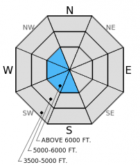
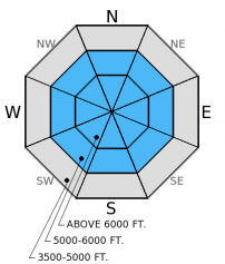
Above 6000 ft. the hazard is CONSIDERABLE on wind loaded slopes steeper than 35 degrees and MODERATE on all other terrain. Below 5000 ft. the hazard is LOW. New snow and moderate to strong winds created fresh wind slabs at upper elevations. If it rains instead of snows at lower elevations the wet avalanche hazard could rise. Spring brings a mixed bag, so pay close attention to changing conditions. See discussion for details on today's rating.

3. Considerable
?
Above 6500 ft.
2. Moderate
?
5000-6500 ft.
1. Low
?
3500-5000 ft.
- 1. Low
- 2. Moderate
- 3. Considerable
- 4. High
- 5. Extreme
-
Type ?
-
Aspect/Elevation ?

-
Likelihood ?CertainVery LikelyLikelyPossible
 Unlikely
 -
Size ?HistoricVery LargeLargeSmall

Winds switched from the predominant southwest to the north-northeast early yesterday morning as rain turned to snow. Snow accumulated quickly yesterday morning and I suspect sensitive wind slabs exist in the alpine near ridgetops. These slabs could be up to 1.5 feet thick in the Flathead Range and Glacier Park, and new snow later today and tonight will add to these slabs. Identify wind loaded terrain near the tops of ridges and carefully assess each slope before comitting to it.
-
Type ?
-
Aspect/Elevation ?

-
Likelihood ?CertainVery LikelyLikelyPossible
 Unlikely
 -
Size ?HistoricVery LargeLargeSmall

Spring weather brings a mixed bag of conditions. Showers are expected today, and given temperatures are expected to be above freezing we could see a bit more rain. Rain on new snow will cause instability. We could see wet, loose avalanches today at the middle elevations involving the new snow from yesterday. Pay close attention to rapidly changing conditions especially rain on new snow as the wet avalanche hazard could rise higher than expected.
Due to limited observations over the past few days, confidence in the hazard rating is low. I suspect high elevation, alpine terrain harbors sensitive wind slabs in the Flathead Range and Glacier NP. In the Swan and Whitefish Range where less snow fell, wind slabs are probably less likely and the hazard is probably lower. However, those ranges are likely to see more snow today and tonight. If substantial snow accumulates through today into tonight, then the hazard could rise on all slopes. Adjust your terrain choices accordingly and pay attention to how the new snow may react. It has been a while since we had new snow so ease into terrain carefully.
After the inundation with rain (over four inches in some locations), the snowpack below the new crust and snow is still wet and moist. When stepping off of your sled or skis, you can still sink through to your knees. Allow the snowpack time to recover from the heavy rain event and use cautious route-finding techniques before committing to a slope. It may still be possible to trigger a slab due to free water moving deeper through the snowpack especially in areas where there was a light or no refreeze. This may be more evident in the Swan Range where less snow fell and temps remained above or hovered around freezing. Uncertainty is high in the Swan Range due to no observations since before the storm. Even though new snow sits atop a crust the snow below that crust is still soft and wet. Wet snow avalanches are notoriously difficult to predict and if you are still sinking above your boot top in snow (even with new snow above) it is time to head for less steep slopes.
The next regularly scheduled advisory will be issued Thursday, March 19, 2015.
Yesterday we attempted to ride our sleds up Pinnacle Creek road in the Middle Fork and were stymied by creek crossings that were causing the road to slump before our eyes (photo). So, we turned around and visited the Essex area instead. Access is becoming an issue these days as rain decimates our low elevation snowpack. We found about 6-8 inches of new snow at 6500-7000 ft. sitting above a thin melt-freeze crust (video). The abundant rain created a wet snowpack below this new snow and crust. There was a also a light mist that created a very thin rain crust at the surface of this new snow.
Other skiers in the Middle Fork observed active wind loading on west-northwest aspects and lingering, isolated pockets of wind slab on east aspects as well.
Clouds and fog limited our visibility so we couldn't assess prior avalanche activity from that area. However, on the drive home we observed several decently sized debris piles in the Nyack Mountain basin of Crystal and Cascadilla Creeks. Again, with limited visibility it was difficult to properly assess the size and distribution.
Heavy rain turned to snow early yesterday morning. Snow amounts totaled 3-7 inches at mountain stations across the advisory area. As of 4:00 a.m. temperatures above 6000 feet range generally range from 9-19º F in Glacier National Park, 33º F in the Swan Range, and low to mid 20s F in the Whitefish Range. Winds are currently moving out of the northeast at 5-6 mph with gusts to 15 mph. Expect increasing showers today with snow levels around 4500-5000 feet lowering through the day.
| 0600 temperature: | 9-33 deg. F. |
| Max. temperature in the last 24 hours: | 21-35 deg. F. |
| Average wind direction during the last 24 hours: | North-Northeast |
| Average wind speed during the last 24 hours: | 5-15 mph |
| Maximum wind gust in the last 24 hours: | 16-20 mph |
| New snowfall in the last 24 hours: | 3-7 inches |
| Total snow depth: | 59-94 inches |
This advisory applies only to backcountry areas outside established ski area boundaries. This advisory describes general avalanche conditions and local variations always occur. This advisory expires at midnight on the posted day unless otherwise noted. The information in this advisory is provided by the USDA Forest Service who is solely responsible for its content.


