| Sunday | Sunday Night | Monday | |
|---|---|---|---|
| Cloud Cover: | Mostly sunny and cool, becoming partly cloudy | Partly cloudy | Colder, return of snow. |
| Temperatures: | 26-36 deg. F. | 11-19 deg. F. | 20-28 deg. F. |
| Wind Direction: | S/SW | S/SW | W/NE |
| Wind Speed: | 5-6 | 5-10 gust 22 | 5-7 gusts 15 |
| Snowfall: | 0 in. | 0 in. | 2-3 in. |
| Snow Line: |
Whitefish Range
Swan Range
Flathead Range and Glacier National Park
How to read the forecast
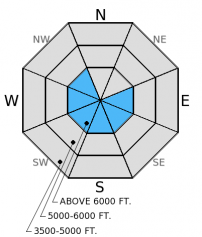
The Hazard above 6000 feet is MODERATE on wind loaded slopes steeper than 35º and LOW on all other terrain. Generally safe conditions exist in most terrain, but a few lingering concerns remain. Recently formed wind slabs are still sensitive to human triggers in steep terrain. In some areas, surface hoar formed over the late-January crust remains reactive. It is unlikely to trigger a persistent slab avalanche, but not impossible. Continue to evaluate the snowpack for weak and reactive layers.

2. Moderate
?
Above 6500 ft.
1. Low
?
5000-6500 ft.
1. Low
?
3500-5000 ft.
- 1. Low
- 2. Moderate
- 3. Considerable
- 4. High
- 5. Extreme
-
Type ?
-
Aspect/Elevation ?

-
Likelihood ?CertainVery LikelyLikelyPossible
 Unlikely
 -
Size ?HistoricVery LargeLargeSmall

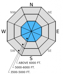
The western portion of the advisory area harbors substantially thinner wind slabs than in areas near the Continental Divide where they are thicker and more dangerous. The moderating wind speeds in the past 24 hours provided a "day off" for these recently formed slabs to settle and adjust. They are already showing signs of improvement, but it is still early, and it remains possible for humans to trigger them in steep terrain. These slabs are easy to identify and avoid (photo), and are fairly small relative to the size of the slope. In most locations they seem confined to just below ridgelines and cross loaded terrain features (photo). Look for rounded pillows of wind drifted snow and where present, avoid convex roll-overs or terrain where getting knocked off of your feet or machine could have high consequence.
-
Type ?
-
Aspect/Elevation ?

-
Likelihood ?CertainVery LikelyLikelyPossible
 Unlikely
 -
Size ?HistoricVery LargeLargeSmall

The late January surface hoar (or facet) and crust layer 1.5-2.5 feet from the surface still exists in our advisory area. Stability test results are variable. In some locations it propagates a fracture and others it does not even fracture, and the distibution is spotty. We haven't observed or received reports of avalanche activity involving this layer in nearly 3 weeks. This makes it unlikely, but not impossible to trigger a persistent slab avalanche. It's still important to dig into the snowpack and identify if the layer is present or not by performing a stability test like the extended column test. If it is reactive keep the slope angle less than 35 degrees and avoid steep, rocky terrain where you are more likely to trigger this layer. Also, please let us know what you find out there. We would love to know where you find this surface hoar and if it is reactive, but also where you do not find it.
Despite the cold temperatures in the morning, it was a beautiful day in the northern Whitefish Range yesterday. We skied and rode in the Red Meadow Lake/Whitefish Mountain area. Along ridgelines and cross loaded features we found recently formed wind slabs that were substantially thinner than we observed in the Skyland Area on Friday (photo,video). Though these slabs were thin and gaining strength, they were still sensitive to human triggering in steep terrain. Stability tests in several snow pits did not produce unstable results on any deeper weak layers in this area. Other recent observations continue to show a spotty and variable distribution of weak snow 1.5-2 feet deep.
I hope yesterday's sunny skies cheered everyone up from the lack of recent snow. This morning temperatures are a few degrees warmer than they started off yesterday. Currently, mountain temperatures range from -1º-11º F, the wind shifted and is blowing 5-8 mph out of the south/southeast. Today should start mostly sunny with light south/southwest winds, temperatures will be slightly warmer than yesterday, rising to the high 20s. Clouds start to build in the area in the afternoon, and by late morning tomorrow we could see some new snow.
| 0600 temperature: | -1-11 deg. F. |
| Max. temperature in the last 24 hours: | 15-22 deg. F. |
| Average wind direction during the last 24 hours: | NE |
| Average wind speed during the last 24 hours: | 5-10 mph |
| Maximum wind gust in the last 24 hours: | 10-15 mph |
| New snowfall in the last 24 hours: | 0 inches |
| Total snow depth: | 64-91 inches |
This advisory applies only to backcountry areas outside established ski area boundaries. This advisory describes general avalanche conditions and local variations always occur. This advisory expires at midnight on the posted day unless otherwise noted. The information in this advisory is provided by the USDA Forest Service who is solely responsible for its content.


