| Thursday | Thursday Night | Friday | |
|---|---|---|---|
| Cloud Cover: | Partly cloudy with lingering snow showers (closer to the Continental Divide). | Partly cloudy with dropping temps. | Mostly cloudy with increasing northeast winds as cold air mass moves in from the north. |
| Temperatures: | 23-33 deg. F. | 8-17 deg. F. | 18-33 deg. F. |
| Wind Direction: | East | East | Northeast |
| Wind Speed: | 5-10 mph with gusts to 15 mph. | 3-5 mph. | 5-10 mph with gusts to 25 mph. |
| Snowfall: | 0 in. | 0 in. | 1 in. |
| Snow Line: |
Whitefish Range
Swan Range
How to read the forecast
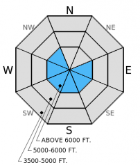
The hazard above 6000 feet is MODERATE on slopes steeper than 35 degrees and LOW on all other terrain. New snow the past 24 hours ranges from 1-8 inches favoring the eastern half of the advisory area. This new snow combined with moderate north to east wind likely created fresh wind slabs. The late January weak layer and crust is spotty and remains mostly dormant, but continues to be reactive in some stability tests. Evaluate snow and terrain carefully today.

2. Moderate
?
Above 6500 ft.
1. Low
?
5000-6500 ft.
1. Low
?
3500-5000 ft.
- 1. Low
- 2. Moderate
- 3. Considerable
- 4. High
- 5. Extreme
-
Type ?
-
Aspect/Elevation ?

-
Likelihood ?CertainVery LikelyLikelyPossible
 Unlikely
 -
Size ?HistoricVery LargeLargeSmall

Wind direction has been quite variable over the past 24 hours and pockets of wind slabs could be found on many aspects. These slabs sit atop a crust from mid-February that provides a good bed surface. These wind slabs also formed over lingering wind slabs from last weekend. Expect wind slabs to be over a foot thick the further east you travel in the advisory area (like the Skyland area) and much shallower to non-existent in the western reaches (like the Whitefish Range). Look for pillows of wind drifted snow particularly near ridge tops and avoid convex rollovers. Cracking and collapsing are signs that these slabs are unstable.
-
Type ?
-
Aspect/Elevation ?

-
Likelihood ?CertainVery LikelyLikelyPossible
 Unlikely
 -
Size ?HistoricVery LargeLargeSmall

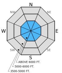
The late January surface hoar (or facet) and crust layer 1.5-2.5 feet from the surface still exists in our advisory area. Stability test results are variable. In some locations it propagates a fracture and others it does not even fracture, and the distibution is spotty. Snowpack tests show that this layer would be difficult to trigger, but the potential for propagation exists. We haven't observed or received reports of avalanche activity involving this layer in over two weeks. This makes it unlikely, but not impossible. It's still important to dig into the snowpack and identify if the layer is present or not by performing a stability test like the extended column test. If it is reactive keep the slope angle less than 35 degrees and avoid steep, rocky terrain where you are more likely to trigger this layer. The cumulative load of new snow plus a human trigger in the eastern edge of the advisory area could reawaken this layer.
The new snow over the previous week fell on a crust from mid-February. Loose snow sluffs are possible on slopes greater than 35 degrees, but should not be very large. However, in high consequence terrain these sluffs can be dangerous.
We have a couple of education opportunities coming up! One is an avalanche awareness day at Noisy Basin this Sunday and another is an Avalanche Skills field course focusing on terrain selection. Check our Education page for the details.
The next regularly scheduled advisory will be issued Saturday, February 28, 2015.
Winter is trying to make a comeback. The eastern edge of the Flathead Range is faring the best. Within the past week, Pike Creek SNOTEL (5900 feet) near Marias Pass has picked up over a foot of new snow. This, of course, translates to more at upper elevations. Last Sunday, observers in the Skyland area noted cracking on wind loaded slopes, but did not see any avalanches (photo). Two parties of skiers in the Middle Fork Sunday reported wind slabs near ridge tops and one party observed small natural wind slab activity from Saturday.
Yesterday we rode throughout the Swan Range from Losty Johnny to Strawberry Mountain searching for lingering wind slabs and the late January crust/surface hoar layer. Results were unreactive in our stability tests on both layers in these areas (video). However, on Monday in the southern Whitefish Range, I found well preserved surface hoar above the late January crust that propagated a fracture in my extended column tests (photo). This same layer was also quite reactive, but it took more force, in Skyland over the weekend (video).
Scattered snow showers and cold air will be the pattern the next few days. Within the past 24 hours the mountains picked up 1-8 inches of new snow. The eastern half of the advisory area fared the best with Pike Creek SNOTEL (5900 feet) near Marias Pass reporting 8 inches of new snow. Noisy Basin SNOTEL (6040 feet) reported about 3 new inches and the Whitefish Range picked up an angry inch or two. As of 4:00 a.m. mountain temperatures range from 1º-16º F. Winds are moving out of the northwest through east this morning at 8-10 mph with gusts to 15 mph. Today, expect lingering snow showers near the Continental Divide with temperatures in the mid- to upper 20s F today. Winds will generally be out of the east-northeast at 5-10 mph. Winds will increase again tomorrow out of the northeast at 10-15 mph gusting to 25 mph.
| 0600 temperature: | 1-16 deg. F. |
| Max. temperature in the last 24 hours: | 19-31 deg. F. |
| Average wind direction during the last 24 hours: | north-northeast |
| Average wind speed during the last 24 hours: | 2-12 mph |
| Maximum wind gust in the last 24 hours: | 14-19 mph |
| New snowfall in the last 24 hours: | 1-8 inches |
| Total snow depth: | 66-93 inches |
This advisory applies only to backcountry areas outside established ski area boundaries. This advisory describes general avalanche conditions and local variations always occur. This advisory expires at midnight on the posted day unless otherwise noted. The information in this advisory is provided by the USDA Forest Service who is solely responsible for its content.


