| Tuesday | Tuesday Night | Wednesday | |
|---|---|---|---|
| Cloud Cover: | Mostly sunny with increasing clouds this evening. | Snow beginning to develop. Increasing winds. | Light snow. |
| Temperatures: | 33-42 deg. F. | 18-25 deg. F. | 25-38 deg. F. |
| Wind Direction: | West-Southwest | West-Southwest | South and East |
| Wind Speed: | 5-10 mph with gusts to 20 mph. | 5-10 mph with gusts to 20 mph. | 5-10 mph. |
| Snowfall: | 0 in. | 1-2 in. | 2 in. |
| Snow Line: |
Whitefish Range
Swan Range
Flathead Range and Glacier National Park
How to read the forecast
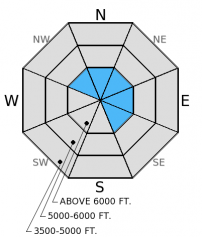
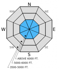
The hazard above 6000 feet is MODERATE on slopes steeper than 35 degrees and LOW on all other terrain. Generally safe avalanche conditions exist on many slopes. However, wind slabs exist at upper elevations near the tops of ridges. The late January crust and surface hoar/facet layer continues to show variable results of instability in stability tests. Evalute each slope carefully before committing to ski or ride on it.

2. Moderate
?
Above 6500 ft.
1. Low
?
5000-6500 ft.
1. Low
?
3500-5000 ft.
- 1. Low
- 2. Moderate
- 3. Considerable
- 4. High
- 5. Extreme
-
Type ?
-
Aspect/Elevation ?

-
Likelihood ?CertainVery LikelyLikelyPossible
 Unlikely
 -
Size ?HistoricVery LargeLargeSmall

Winds have shifted back to the normal prevailing southwest direction and picked up a bit of speed overnight. Winds will increase through the day today as well. With enough new snow to blow around, I would expect to find wind slabs near ridge tops at the upper most elevations in our advisory area. These slabs could be over a foot thick, but should not be very wide. In high consequence terrain they could take you for a nasty ride. Regardless, look for obvious sings of instability like cracking or collapsing and assess slope stability before committing to ski or ride.
-
Type ?
-
Aspect/Elevation ?

-
Likelihood ?CertainVery LikelyLikelyPossible
 Unlikely
 -
Size ?HistoricVery LargeLargeSmall

We have not observed nor received any reports of avalanche activity on the late January crust/weak layer in nearly two weeks. The problem is that this layer still exhibits signs of instability in stability tests. This layer is about 1.5 - 2.5 feet below the surface. The results are variable (some times it propagates fractures and some time it does not) and the locations are spotty. This is enough information to make us pause and assess each slope. The only way to determine the reactivity is to dig into the slope and perform a stabilty test like the extended column test. If it's reactive, then choose slopes less than 35 degrees in steepness.
Wet snow avalanche hazard could become a problem later today if the clouds don't roll in until later. Abundant sunshine, temperatures creeping above freezing, and new snow from last weekend could be enough of a recipe for wet loose avalanches on sunnny aspects. If you begin to see roller balls or pinwheels on steep, sunny terrain, then it's time to move to shadier slopes. Glide cracks still lurk throughout the advisory area and their unpredictability should cause you to just avoid slopes with glide cracks present.
The bit of new snow from the weekend provided a nice little refresh to skiing and riding conditions. A bit of dust on crust on the sunny aspects is nice and shadier, sheltered aspects now harbor soft enjoyable snow. With this new snow and wind came some small wind slabs near ridge tops. Observers in the Skyland area (Flathead Range) over the weekend found sensitive wind slabs up to 20 inches thick that cracked easily, but did not produce avalanches (photo). They also found facets above the late January crust about 2 feet from the surface that propagated fractures in their extended column tests (video). Skiers in the Middle Fork on Sunday reported touchy wind slabs near the tops of ridges and some recent natural wind slab activity from likely Saturday.
Yesterday, I was on the hunt to determine the distribution and reactivity of the late January crust/weak layer in the southern Whitefish Range. I wanted definitive results, but at the end of the day was left scratching my head. In some of my pits I found surface hoar that was both reactive and non-reactive. In other pits I found no surface hoar. In one pit near Grizzly Notch (near Skook Peak), I found well preserved surface hoar that propagated a fracture with moderate force (photo). Skiers in the Jewel Basin, Swan Range, were also able to get this layer to propagate a fracture with hard force (observation).
One more day of high pressure before cold air and a bit of snow move into the region tonight. As of 4:00 a.m. mountain temperatures range from 11º-22º F with winds moving out of the southwest at 6-10 mph and gusting to 15 mph. Today, expect sunny skies with increasing clouds as the day progresses. Temperatures will rise to the mid-30s F above 6000 feet with winds out of the southwest at 8-15 mph with gusts to 30 mph. Snow should begin tonight but it appears most of it will be focused at the northern and eastern reaches of our advisory area. We could see a few inches by the end of the day Wednesday.
| 0600 temperature: | 11-22 deg. F. |
| Max. temperature in the last 24 hours: | 27-33 deg. F. |
| Average wind direction during the last 24 hours: | West-Southwest |
| Average wind speed during the last 24 hours: | 2-14 mph |
| Maximum wind gust in the last 24 hours: | 16-21 mph |
| New snowfall in the last 24 hours: | 0 inches |
| Total snow depth: | 64-92 inches |
This advisory applies only to backcountry areas outside established ski area boundaries. This advisory describes general avalanche conditions and local variations always occur. This advisory expires at midnight on the posted day unless otherwise noted. The information in this advisory is provided by the USDA Forest Service who is solely responsible for its content.


