| Tuesday | Tuesday Night | Wednesday | |
|---|---|---|---|
| Cloud Cover: | Sunny and warming. | Clear. | Sunny and warm. |
| Temperatures: | 31-40 deg. F. | 19-26 deg. F. | 36-45 deg. F. |
| Wind Direction: | West-Southwest | West-Southwest | Southwest |
| Wind Speed: | 1-5 mph. | 4-6 mph. | 5-10 mph with gusts to 20 mph near the Cont. Divide. |
| Snowfall: | 0 in. | 0 in. | 0 in. |
| Snow Line: |
Whitefish Range
Swan Range
How to read the forecast
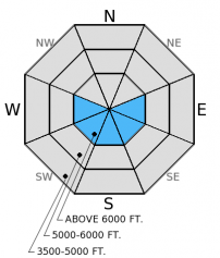
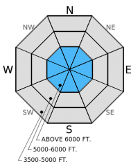
The hazard today is MODERATE above 6000 ft. due to a layer of weak snow about 1.5 - 2 feet from the surface as well as the potential for loose, wet snow avalanches on sunny aspects as the day progresses. The hazard below 6000 ft. is LOW. Evaluate snow and terrain carefully today by digging into the snow to identify potential weak layers. Avoid being on sunny slopes as the day warms and move to shadier slopes.

2. Moderate
?
Above 6500 ft.
1. Low
?
5000-6500 ft.
1. Low
?
3500-5000 ft.
- 1. Low
- 2. Moderate
- 3. Considerable
- 4. High
- 5. Extreme
-
Type ?
-
Aspect/Elevation ?

-
Likelihood ?CertainVery LikelyLikelyPossible
 Unlikely
 -
Size ?HistoricVery LargeLargeSmall

Temperatures should warm above freezing today with sunny skies making wet, loose avalanches a problem as the day progresses. A melt-freeze crust from Valentine's Day provides a great bed surface for the bit of new snow to slide on as a loose avalanche. These wet loose avalanches should be small, but even a small avalanche can have big consequences in certain terrain (like terrain traps or above cliffs). Rollerballs and pinwheels are bulls-eye clues of wet snow instability and mean its time to move to shadier slopes. Avoid sunny slopes as the day progresses.
-
Type ?
-
Aspect/Elevation ?

-
Likelihood ?CertainVery LikelyLikelyPossible
 Unlikely
 -
Size ?HistoricVery LargeLargeSmall

Weak snow about 1.5 - 2.5 feet from the surface is variable throughout the advisory area. In extended column tests this layer propagates fractures in some areas but not others. Because of this it is important to dig into the snow, identify the weak layer, and assess its reactivity by performing a stability test (like an extended column test). You are more likely to trigger this layer in steep, rocky areas where the snowpack is more shallow. So, avoid those areas and choose slopes less than 35 degrees when this layer is present.
As spring-like conditions return we could see an increased likelihood of wet snow avalanche problems. Along with wet, loose avalanches glide avalanches could become a wet snow problem as temperatures warm and there is abundant sunshine. Avoid slopes with glide cracks present. Glide cracks can fail at once or in stages. Some glide cracks in the Swan Range earlier this season failed as separate avalanches over a period of 5 days. So, even slopes that have already avalanched can slide again. These avalanches are notoriously difficult to predict, but can be large because they involve the entire snowpack. Cornices could also soften and fail as temps rise and the sun shines. So, stay well back and out from under large cornices (photo).
Clear skies allowed for great views, but the variable cloud cover and fairly chilly temps never allowed the snow surface to soften yesterday above 6000 ft. The riding and skiing was pretty scratchy. We found thin wind slab pockets above 6000 feet as well as a layer of weak facets and surface hoar 1.5 - 2 feet from the surface in the Mt. Aeneas area of the Swan Range yesterday. The surface hoar is fairly well preserved on shaded aspects above 6500 ft. and did not propagate fractures in this location. However, moist, weak snow about 1.5 feet below a hard slab and crust on a sunny aspect propagated a fracture with moderate force in every test (video). Recent observations from the Whitefish Range show a layer of surface hoar and/or facets surrounding the late January melt-freeze crust still propagates fractures in extended column tests with hard force (video and photo).
Skiers at Marias Pass observed about 8 inches of new snow and stuck to low angled, sheltered slopes (observation). We have no observations from upper elevations in this area so confidence is low regarding both hazard and wind slab problems in the far eastern portion of our advisory area. Wind slabs are likely to be thicker in those areas.
A ridge of high pressure builds over the next 48 hours bringing sunny skies and warm temperatures. On Sunday, a moist airmass brushed the far eastern edge of the advisory area leaving 8 inches of new snow at Marias Pass, but denying the rest of the area except for 1-2 inches above 6000 feet west of the Continental Divide. Pike Creek SNOTEL at 5900 ft. near Marias Pass gained 0.7 inches of snow water equivalent and 8 inches of new snow. As of 4:00 am mountain temperatures range from 15º - 21º F with Flattop Mt. SNOTEL in GNP recording 3º F. Winds are moving out of the southwest at 3-6 mph with gusts to 14 mph. Today, expect sunny skies, temperatures warming to the mid-30s to low 40s, and continued light southwest winds.
| 0600 temperature: | 3-21 deg. F. |
| Max. temperature in the last 24 hours: | 21-31 deg. F. |
| Average wind direction during the last 24 hours: | northeast shifting to southwest |
| Average wind speed during the last 24 hours: | 2-8 mph |
| Maximum wind gust in the last 24 hours: | 9-17 mph |
| New snowfall in the last 24 hours: | 0 inches |
| Total snow depth: | 60-89 inches |
This advisory applies only to backcountry areas outside established ski area boundaries. This advisory describes general avalanche conditions and local variations always occur. This advisory expires at midnight on the posted day unless otherwise noted. The information in this advisory is provided by the USDA Forest Service who is solely responsible for its content.


