| Thursday | Thursday Night | Friday | |
|---|---|---|---|
| Cloud Cover: | High pressure with potential for light rain showers later this afternoon. | Mostly cloudy with light showers possible. | Partly cloudy. |
| Temperatures: | 38-48 deg. F. | 30-35 deg. F. | 41-49 deg. F. |
| Wind Direction: | Southwest | Southwest | Southwest |
| Wind Speed: | 5-10 mph with gusts to 20 mph. | 5-10 mph. | 4-6 mph. |
| Snowfall: | 0-1 in. | 0-1 in. | 0 in. |
| Snow Line: |
Whitefish Range
Swan Range
Flathead Range and Glacier National Park
How to read the forecast
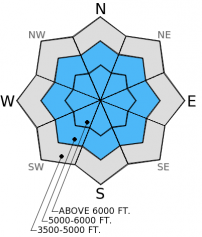
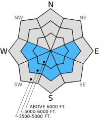
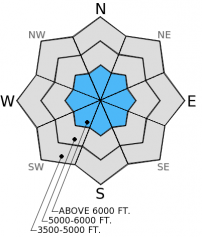
The hazard is MODERATE above 5500 feet due to lingering storm and persistent slabs with the potential for wet, loose avalanches as the day warms. Below 5500 feet the hazard is LOW. Since last Thursday through Tuesday over 1-2 feet of heavy, wet snow accumulated above 6000 feet. Human triggered avalanches are possible so evaluate snow and terrain carefully today. The hazard could be higher if skies clear more than expected and wet snow avalanches become more likely.

2. Moderate
?
Above 6500 ft.
2. Moderate
?
5000-6500 ft.
1. Low
?
3500-5000 ft.
- 1. Low
- 2. Moderate
- 3. Considerable
- 4. High
- 5. Extreme
-
Type ?
-
Aspect/Elevation ?

-
Likelihood ?CertainVery LikelyLikelyPossible
 Unlikely
 -
Size ?HistoricVery LargeLargeSmall

Both lingering storm and wind slabs of wet, heavy snow are still a concern. Storm and wind slabs can take up to a week to stabilize. The series of wet storms just ended about 36 hours ago, and while natural activity appeared limited, it is still possible to trigger a storm slab on steep slopes (35 degrees and steeper). Wind slabs from this storm (so basically thicker storm slabs) exist on leeward and cross loaded slopes mostly near the tops of ridges. These storm and wind slabs can be up to 2.5 feet thick, and are more easily triggered at upper elevations. Identify wind loaded slopes and dig into the top part of the snowpack to determine the reactivity of these storm and wind slabs.
-
Type ?
-
Aspect/Elevation ?

-
Likelihood ?CertainVery LikelyLikelyPossible
 Unlikely
 -
Size ?HistoricVery LargeLargeSmall

Natural wet, loose avalanches occured during this series of storms up to size D2 (large enough to bury, injure, or kill a person). Today, these avalanches are possible due to warming temps and partly clearing skies. If skies clear more than expected, then we could see more widespread wet, loose activity. Pay attention to changing conditions and adapt your plan accordingly. Rollerballs and pinwheels are signs that the wet snow hazard is increasing so moving to shadier slopes and avoiding sunny aspects is a good way to manage this problem.
-
Type ?
-
Aspect/Elevation ?

-
Likelihood ?CertainVery LikelyLikelyPossible
 Unlikely
 -
Size ?HistoricVery LargeLargeSmall

Because observations are limited we can't quite take the persistent slab problem off the list. The surface hoar/crust from late January was the failure layer for many of the storm slabs this past weekend, and it is still possible to trigger a slab involving this layer or the mid-January crust. Deeper weak layers are largely unreactive at this point. Locations where it may be easier to trigger deeper persistent slabs include steep, rocky slopes with a shallow snowpack. Dig down into the snowpack to assess these deeper insabilities and avoid slopes where they are reactive in stability tests.
If skies clear more than expected today natural and human triggered wet, loose avalanches will become more likely and the avalanche hazard will increase. The potential for slab activity could increase as well with such a sustained period of above freezing temperatures. Sunshine will only serve to increase the wet snow hazard. Pay attention to the weather and watch for signs of wet snow instability. Skies should clear more tomorrow so expect the wet snow hazard to increase. Avoid sunny aspects and move to shadier locations as slopes move into the sun.
The next regularly scheduled advisory will be issued Saturday, February 14, 2015.
Currently, it's a tale of two worlds. Below about 5500 feet, the snowpack is more spring like and disappering at the lowest elevations . At the upper elevations it is still mostly winter with rain mixed in from the series of warm, wet storms. It wasn't all rain at those elevations, though. In the Swan Range yesterday we found about 2 feet of heavy, moist snow with a couple of rain crusts mixed in on a wind loaded slope around 7000 feet. On non-wind loaded slopes there was about a foot with those same rain crusts (photo). Visibility was limited but we observed some natural avalanche activity from the past few days in the form of both dry and wet, loose avalanches and small storm slabs (photo1, photo2). Similar conditions existed in the Flathead Range earlier in the week (video).
Stability tests results showed partial propagation within the storm snow and around the new rain crusts, and the late January crust showed no reactivity. The surface hoar above this crust appears to be mostly decomposing and moist. However, many avalanches during the storm over the weekend failed on this layer (photo), and could still be present in some locations.
Field data are limited over the past week with only two public observations aside from our own. I know it's been wet and fairly nasty, but if you are in the backcountry please let us know what you are seeing (even if you aren't seeing avalanches). Your observations are valuable and help make the advisory more robust. Thanks!
High pressure continues today over the region with mostly dry conditions through early Saturday. As of 4:00 am mountain temperatures range from 28º-35º F with winds moving out of the southwest at 9-11 mph gusting to 25 mph. Today, mostly to partly cloudy skies will prevail. Temperatures will be in the upper 30s to mid 40s F with winds out of the southwest at 5-10 mph gusting to 25 mph except locations closer to the Continental Divide where average winds will be 10-15 mph with gusts to 40 mph. Light showers could occur this afternoon as a small disturbance moves through the ridge.
| 0600 temperature: | 28-35 deg. F. |
| Max. temperature in the last 24 hours: | 32-39 deg. F. |
| Average wind direction during the last 24 hours: | Southwest |
| Average wind speed during the last 24 hours: | 1-11 mph |
| Maximum wind gust in the last 24 hours: | 16-31 mph |
| New snowfall in the last 24 hours: | 1 inches |
| Total snow depth: | 63-92 inches |
This advisory applies only to backcountry areas outside established ski area boundaries. This advisory describes general avalanche conditions and local variations always occur. This advisory expires at midnight on the posted day unless otherwise noted. The information in this advisory is provided by the USDA Forest Service who is solely responsible for its content.


