| Tuesday | Tuesday Night | Wednesday | |
|---|---|---|---|
| Cloud Cover: | Snow and rain. Snow level 4500-5000 feet. Decreasing precipitation throughout the day. | Clearing with high pressure building. Valley temperature inversions with warm mountain temperatures. | Above normal mountain temps with clearing skies. |
| Temperatures: | 34-43 deg. F. | 27-33 deg. F. | 38-48 deg. F. |
| Wind Direction: | West-Southwest | West-Southwest | Southwest |
| Wind Speed: | 5-10 mph. | 5-10 mph. | 5-10 mph. |
| Snowfall: | 2-4 in. | 0 in. | 0 in. |
| Snow Line: |
Whitefish Range
Swan Range
Flathead Range and Glacier National Park
How to read the forecast
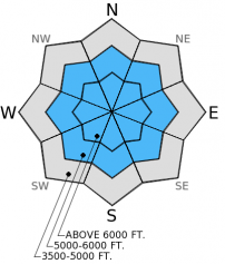
Heavy, wet snow and rain overnight continuing into today created unstable conditions. The hazard is CONSIDERABLE above 5000 feet and MODERATE below 5000 feet. Human triggered avalanches are likely and natural avalanches are possible today. Since last Thursday a series of warm, wet storms deposited substantial new snow above 6500 feet and rain on snow below this elevation. Dangerous avalanche conditions exist and cautious route-finding and conservative decision making are essential.

3. Considerable
?
Above 6500 ft.
3. Considerable
?
5000-6500 ft.
2. Moderate
?
3500-5000 ft.
- 1. Low
- 2. Moderate
- 3. Considerable
- 4. High
- 5. Extreme
-
Type ?
-
Aspect/Elevation ?

-
Likelihood ?CertainVery LikelyLikelyPossible
 Unlikely
 -
Size ?HistoricVery LargeLargeSmall

New snow amounts are up to 7 inches as of this morning, but the amount of liquid water (weight) in this snow is substantial. Also, I expect more snow and rain through at least the morning. This will create new storm slabs around a foot thick or more. Winds were light with moderate gusts, but I suspect there are a few wind loaded slopes today where these slabs could be up to 2 feet thick. This new snow is dense and heavy and fell on a rain crust in all but the highest elevations which provides a great bed surface for this new snow to slide on. Storm slabs over the weekend failed on the late January surface hoar/crust combination and we could see storm slabs failing on that layer again today making even thicker slabs. Today, stick to low angled slopes and allow this new snow time to settle.
-
Type ?
-
Aspect/Elevation ?

-
Likelihood ?CertainVery LikelyLikelyPossible
 Unlikely
 -
Size ?HistoricVery LargeLargeSmall

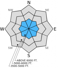
Yesterday, small point release avalanches occurred as soon as the temperature rose just a bit. We were easily able to trigger sluffs of the new snow on slopes steeper than 35 degrees. They ran on the rain crust quite a ways. With even more new snow I expect both wet and dry loose avalanches (depending on the elevation) to be easily triggered and entrain enough snow to take you for a good ride and possible bury a person. Again, stick to lower angled slopes and keep in mind that even small loose avalanches can kill in high consequence terrain like terrain traps.
-
Type ?
-
Aspect/Elevation ?

-
Likelihood ?CertainVery LikelyLikelyPossible
 Unlikely
 -
Size ?HistoricVery LargeLargeSmall

Visiblity has been very limited during this series of storms so observations are limited, and it's hard to know if any avalanches failed on more deeply buried weak layers. Our stability tests indicate the potential exists, but is less likely and more isolated than the other avalanche problems. Given the amount of rain these persistent slab could also manifest themselves as wet slabs. The mid-January crust/facet/surface hoar layer is one such layer that could be an isolated concern. Dig down into the snowpack and perform stability tests to identify any potential persistent weak layers and assess their reactivity. Avoid steep, rocky slopes where these layers are more easily triggered.
Snowfall amounts and precipitation in the past 24 hours vary throughout the advisory area. Since our observations have been very limited both in quantity and extent there is a fair amount of uncertainty in the forecast. The advisory is a starting point. Use it as just one tool in your backcountry decision making toolbox, and continually assess conditions for instability as you travel in the backcountry. The hazard may be higher or lower in the area in which you choose to recreate.
The next regularly scheduled advisory will be issued Thursday, February 12, 2015.
Over the weekend a natural avalanche cycle occurred that included both storm and wet loose avalanches. At least one slab avalanche in the Middle Fork of the Flathead Range was estimated at about 900 feet wide. Todd observed numerous smaller natural avalanches above 5500 feet in the northern Whitefish Range that occurred Friday and Saturday (photo 1, photo 2). We also observed a few wet, loose avalanches from the previous 3 days in Rescue Creek in the Flathead Range yesterday.
A new rain crust formed up to at least 6500 feet (or higher) as a result of this series of warm storms. Yesterday in the Middle Fork corridor of the Flathead Range about four inches of snow accumulated on this crust above 6000 feet, and this new snow sluffed very easily on slopes steeper than 35 degrees (video). We observed a wet to moist snowpack up to 6500 feet with melt-freeze and rain crusts mixed in throughout (profile photo). Extended column tests produced fractures but no propagation underneath the new rain crust as well as above the late January melt-freeze crust.
We received no other observations in the past 3 days.
The series of storms that began last Thursday will continue for one more day before high pressure sets in tomorrow. In the past 24 hours, snow fell above 6000-6500 feet with rain below. Snow water equivalent (SWE) totals within that time range from 0.5 inches to 1.1 inches in the Flathead and Whitefish Ranges (up to 6 inches of snow) to 1.5 inches in the Swan Range (up to 7 inches of snow). As of 4:00 am temperatures range from 31º-38º F with winds moving out of the southwest at 2-11 mph with gusts to 16 mph. Today, temperatures should drop a bit to the lower 30s above 5000 feet with snow levels lowering to 4500-5000 feet. Winds will be out of the west-southwest at 5-10 mph with gusts to 25 mph. Another few inches of snow is expected to accumulate by the end of the day.
| 0600 temperature: | 29-34 deg. F. |
| Max. temperature in the last 24 hours: | 30-38 deg. F. |
| Average wind direction during the last 24 hours: | Southwest |
| Average wind speed during the last 24 hours: | 2-11 mph |
| Maximum wind gust in the last 24 hours: | 19-30 mph |
| New snowfall in the last 24 hours: | 1-7 inches |
| Total snow depth: | 62-91 inches |
This advisory applies only to backcountry areas outside established ski area boundaries. This advisory describes general avalanche conditions and local variations always occur. This advisory expires at midnight on the posted day unless otherwise noted. The information in this advisory is provided by the USDA Forest Service who is solely responsible for its content.


