| Sunday | Sunday Night | Monday | |
|---|---|---|---|
| Cloud Cover: | Rain/snow with high snow levels tapering mid morning and becoming partly cloudy. | Rain/snow resumes | Continued rain/snow, begin cooling trend |
| Temperatures: | 37-47 deg. F. | 28-33 deg. F. | 38-46 deg. F. |
| Wind Direction: | SW | S | S/SW |
| Wind Speed: | 12-18 gusts 28-37 | 5-10 | 5-10 |
| Snowfall: | 0-1 in. | 0-2 in. | 0-5 in. |
| Snow Line: |
Swan Range
How to read the forecast
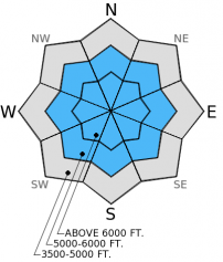
The northern part of the advisory area was strongly favored with recent precipitation. Wet, heavy snow or rain, warm temperatures and gusty winds in the Swan Range still contributed to dangerous conditions. The hazard in CONSIDERABLE above 5000 feet. Human triggered loose, wet and storm slab avalanches are likely. Careful snow pack evaluation and conservative terrain selection are important.

3. Considerable
?
Above 6500 ft.
3. Considerable
?
5000-6500 ft.
2. Moderate
?
3500-5000 ft.
- 1. Low
- 2. Moderate
- 3. Considerable
- 4. High
- 5. Extreme
-
Type ?
-
Aspect/Elevation ?

-
Likelihood ?CertainVery LikelyLikelyPossible
 Unlikely
 -
Size ?HistoricVery LargeLargeSmall

Before this series of storms moved into the area large surface hoar developed (and was preserved) on top of a thick melt-freeze crust in most locations across the region. Now, wet, heavy snow continues to pile up in the upper elevations and put a large amount of stress on this weak layer. Additionally, the winds in the past few days have been strong enough to drift the heavy snow on the high ridgelines and further thicken these slabs. With the potential for the clouds to move out we could also see increased activity today with above freezing temperatures and ample sun exposure. Choose conservative, low angle terrain and carefully assess each slope you intend to ski or ride.
-
Type ?
-
Aspect/Elevation ?

-
Likelihood ?CertainVery LikelyLikelyPossible
 Unlikely
 -
Size ?HistoricVery LargeLargeSmall

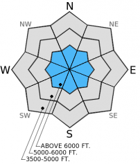
Still only a marginal re-freeze in some locations over night, but nothing that would have locked up the surface snow. Natural loose, wet avalanches remain possible today. At mid-elevations there is between 8-12 inches of wet snow ontop of a melt-freeze crust that would love a human trigger on a steep slope. With the smooth bed surface these avalanches can get a good head of steam and entrain a lot of snow. Where the snow is wet (please tell us if you find dry snow) stick to lower angle slopes and avoid steep roll-overs and terrain traps like narrow gullies and creek beds. In lower elevations, loose, wet avalanches will be small but can have big consequences if encountered in the wrong terrain like cliff areas, heavy timber, or narrow gullies.
-
Type ?
-
Aspect/Elevation ?

-
Likelihood ?CertainVery LikelyLikelyPossible
 Unlikely
 -
Size ?HistoricVery LargeLargeSmall

As mentioned before, surface hoar formed in mid-January has produced varying results in recent stability tests across the area. In some locations it propagates fractures in extended column tests and in others it is barely discernable. This weak layer is getting quite a test with the recent load. Continue to dig the 2-3 feet into the snow and look for this layer. Where present and reactive, stay on simple, low angle terrain and avoid shallow, rocky areas where you are the most likely to trigger it.
Numerous natural avalanches have been observed in the Flathead and Whitefish Ranges since Friday. On Friday there was activity reported in the John F Stevens Canyon and a natural avalanche on Nyack Mountain in the Flathead Range with a crown width estimated at 1000 feet. Skiers in Canyon Creek in the southern Whitefish Range triggered a small storm slab and also noted multiple piles of avalanche debris in the canyon.
Yesterday, we were in the Red Meadow and Stryker Ridge areas in the northern Whitefish Range. There was evidence of widespread natural avalanche activity in this area from the previous day (photo) and the cycle continued into the day yesterday. We found debris across the road into Red Meadow lake and several other avalanches that stopped near the road (photo). The snow pack structure in this area is similar to other locations. There is a firm melt-freeze crust with weak (faceted) snow below and surface hoar above with 8-18 inches of recent wet, heavy snow on top.
Wet, heavy snow and rain continued over night. In the past 24 hours we picked up an additional 0.6-1.2 inches of snow water equivalent. These storms continue to favor the north part of the advisory area. Storm totals since the onset of consistent precipitation on Wednesday night are pretty impressive. Flattop Mountain SNOTEL recorded 4 inches of water in this period. Currently, mountain temperatures range from 29º-35º F with southwest winds blowing 5-15 mph. For today, warm temperatures will persist in the region. Rain/snow should taper by mid-morning and become partly cloudy by the afternoon. Another moist system is expected to impact the area tonight.
| 0600 temperature: | 29-35 deg. F. |
| Max. temperature in the last 24 hours: | 31-37 deg. F. |
| Average wind direction during the last 24 hours: | SW |
| Average wind speed during the last 24 hours: | 5-15 mph |
| Maximum wind gust in the last 24 hours: | 15-30 mph |
| New snowfall in the last 24 hours: | 0-5 inches |
| Total snow depth: | 60-91 inches |
This advisory applies only to backcountry areas outside established ski area boundaries. This advisory describes general avalanche conditions and local variations always occur. This advisory expires at midnight on the posted day unless otherwise noted. The information in this advisory is provided by the USDA Forest Service who is solely responsible for its content.


