| Thursday | Thursday Night | Friday | |
|---|---|---|---|
| Cloud Cover: | Increasing precipitation and rising temperatures/snow levels. | Continued precipitation and strong winds. | Rising snow levels and heavy precipitation. |
| Temperatures: | 37-46 deg. F. | 32-36 deg. F. | 37-45 deg. F. |
| Wind Direction: | Southwest | Southwest | Southwest |
| Wind Speed: | 10-15 mph with gusts to 35 mph. | 15-22 mph with gusts to 41 mph. | 15-20 mph with gusts to 45 mph. |
| Snowfall: | 2-5 in. | 0-5 in. | 0-5 in. |
| Snow Line: |
Whitefish Range
Swan Range
Flathead Range and Glacier National Park
How to read the forecast
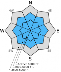
The avalanche hazard will increase throughout the day. The hazard will rise to CONSIDERABLE on all slopes above 5000 feet as heavy, wet snow accumulates over a weak layer of buried surface hoar that sits on a crust. Dangerous avalanche conditions will develop and human triggered avalanches will become more likely as the day progresses. Natural activity will also be possible. Expect the hazard to rise over the next few days as this potent storm moves through the advisory area.

3. Considerable
?
Above 6500 ft.
3. Considerable
?
5000-6500 ft.
2. Moderate
?
3500-5000 ft.
- 1. Low
- 2. Moderate
- 3. Considerable
- 4. High
- 5. Extreme
-
Type ?
-
Aspect/Elevation ?

-
Likelihood ?CertainVery LikelyLikelyPossible
 Unlikely
 -
Size ?HistoricVery LargeLargeSmall

Up to 10 inches of heavy, wet new snow is expected above 6000 ft. by the end of the day today (favoring the Glacier Park area). This new snow will fall on 5-8 inches of snow from earlier in the week creating slabs up to 1.5 feet thick. Moderate to strong winds (up to 50 mph) accompany this storm and will add to existing wind slabs on leeward slopes at upper elevations. The bond between this new snow and the late January buried surface hoar/crust combination is weak and natural avalanches could become more likely as the day progresses. Pay attention to these changing conditions and watch for storm and wind slabs to become more sensitive to human triggering. Reduce the time spent in avalanche terrain today as the snow piles up and rain falls on new snow.
-
Type ?
-
Aspect/Elevation ?

-
Likelihood ?CertainVery LikelyLikelyPossible
 Unlikely
 -
Size ?HistoricVery LargeLargeSmall

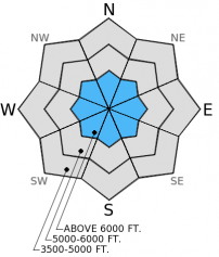
The persistent weak layers in our snowpack have not quite gone away enough to take the persistent slab problem off the list. These layers include the mid-January buried surface hoar layer (about 2 feet from the surface) which shows variable reactivity across the advisory. In some stability tests it propagates fractures and in others it does not even fracture. Then there is the mid-December layer which has remained quiet for about nine days, but cannot be ruled out to become reactive again with a new load expected. These layers are more likely triggered on steep, rocky slopes with a shallow snowpack so it is best to avoid these areas for now.
-
Type ?
-
Aspect/Elevation ?

-
Likelihood ?CertainVery LikelyLikelyPossible
 Unlikely
 -
Size ?HistoricVery LargeLargeSmall

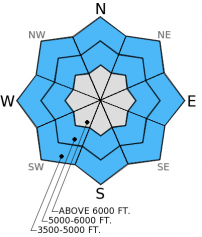
With rain falling at low to mid-elevations today wet loose avalanches will become possible. At lower elevations there is only a few inches that the rain can impact. However, as rain levels increase it will fall on more snow. Thus, rain induced wet avalanches are possible throughout the day. Rollerballs and small point releases are a good indication the snow surface is becoming unstable and it's time to move out of avalanche terrain. Even small avalanches can have big consequences in terrain traps like gullies and creek beds.
The avalanche hazard will increase as the day progresses. Dangerous avalanche conditions could develop more quickly depending on the timing and intesity of precipitation today. Because of this it is important to pay close attention to changing conditions and adapt your plan as necessary. The existing snow structure (surface hoar/crust combination) lends itself to a very unstable snowpack once we add more load to it. By tomorrow we could be tickling the belly of High avalanche hazard depending on how this storm progresses so stay tuned.
The next regularly scheduled advisory will be issued Saturday, February 7, 2015, but we will likely update the advisory tomorrow given the expected conditions.
Observations across the advisory area reveal similar patterns. In most locations surface hoar from late January sits atop a melt-freeze crust with weak snow underneath (photo). The surface hoar above the crust and facets below the crust are both reactive in stability tests (video1, video2). Wind slabs exist at the upper elevations near ridgetops and skiers in the Marion Lake area near Essex reported easily triggering them earlier in the week. The mid-January buried surface hoar layer displays variable stabilty test results throughout the advisory area (some locations it propagates fractures and others it produces no fracture), and the mid-December crust/facet layer is largely unreactive at this point.
A series of storms with subtropical origins (read: wet) will march through the advisory area over the next few days. Precipitation began overnight with 1-2 inches of accumulation as of 4:00 am. Mountain weather stations report temperatures ranging from 24º to 33º F with southwest winds moving at 5-10 mph with gusts to 17 mph. Today, expect precipitation to continue with increasing intensity. Snow levels will be around 5000-6000 feet and will unfortunately increase throughout the day. Accumulation of wet, heavy snow above 6000 feet will be in the 5-10 inch range by this afternoon with Glacier Park and the Flathead Range receiving the most precipitation.
| 0600 temperature: | 26-33 deg. F. |
| Max. temperature in the last 24 hours: | 33 deg. F. |
| Average wind direction during the last 24 hours: | Southwest |
| Average wind speed during the last 24 hours: | 4-9 mph |
| Maximum wind gust in the last 24 hours: | 17-20 mph |
| New snowfall in the last 24 hours: | 1-2 inches |
| Total snow depth: | 60-87 inches |
This advisory applies only to backcountry areas outside established ski area boundaries. This advisory describes general avalanche conditions and local variations always occur. This advisory expires at midnight on the posted day unless otherwise noted. The information in this advisory is provided by the USDA Forest Service who is solely responsible for its content.


