| Tuesday | Tuesday Night | Wednesday | |
|---|---|---|---|
| Cloud Cover: | Mostly cloudy with lingering snow. | Mostly cloudy with some snow. Colder air mass nudges west over Continental Divide bringing generally east winds. | Cloudy and mostly dry with winds switching back to southwest. |
| Temperatures: | 28-40 deg. F. | 12-24 deg. F. | 29-37 deg. F. |
| Wind Direction: | West-Southwest | East | Southwest |
| Wind Speed: | 7-12 mph with gusts to 25 mph. | 5-10 mph. | 5-10 mph. |
| Snowfall: | 1-3 in. | 1-2 in. | 0 in. |
| Snow Line: |
Whitefish Range
Swan Range
Flathead Range and Glacier National Park
How to read the forecast
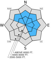
New snow (4-10 inches) accompanied by moderate to strong winds over the past 48 hours created sensitive wind slabs. These new slabs sit on top of a weak layer of buried surface hoar and a crust. This combination makes the hazard CONSIDERABLE on wind loaded slopes above 5000 feet. Human triggered avalanches are likely in wind loaded terrain today. All other terrain is rated MODERATE where human triggered avalanches are possible.

3. Considerable
?
Above 6500 ft.
3. Considerable
?
5000-6500 ft.
2. Moderate
?
3500-5000 ft.
- 1. Low
- 2. Moderate
- 3. Considerable
- 4. High
- 5. Extreme
-
Type ?
-
Aspect/Elevation ?

-
Likelihood ?CertainVery LikelyLikelyPossible
 Unlikely
 -
Size ?HistoricVery LargeLargeSmall

Moderate to strong winds combined with new snow over the past 2 days created wind slabs on leeward aspects as well as cross-loaded slopes. These wind slabs were up to 10 inches thick and very sensitive yesterday. They formed on a weak layer of buried surface hoar, so expect them to be even more sensitive and thicker after last night's new snow and wind. Natural wind slab avalanches may be possible today. Look for and avoid convex pillow of wind-drifted snow on the lee sides of ridges and in cross-loaded gullies. Dig down into the surface snow to determine the sensitivity of these wind slabs.
-
Type ?
-
Aspect/Elevation ?

-
Likelihood ?CertainVery LikelyLikelyPossible
 Unlikely
 -
Size ?HistoricVery LargeLargeSmall

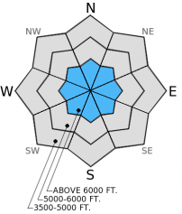
Storm slabs could be a problem at the upper elevations today. The Swan Range, in particular, received 1.4 inches of SWE over the past 48 hours. Enough snow fell on the surface hoar/crust layers that caution is warranted. With this newly buried surface hoar layer there is uncertainty as to how much of a load it can handle before it avalanches. Therefore, carefully evaluate the snowpack before choosing to ski or ride a slope to determine how cohesive and sensitive these storm slabs can be after last night's new snow and stick to simple, low angled terrain.
-
Type ?
-
Aspect/Elevation ?

-
Likelihood ?CertainVery LikelyLikelyPossible
 Unlikely
 -
Size ?HistoricVery LargeLargeSmall

There are 2 persistent weak layers in the snowpack right now.
1. The mid-December crust/facet layer continues to produce unstable results in stability tests in isolated locations.
2. The mid-January buried surface hoar layer is variable across the area and propagates fractures in some locations and not in others.
Avalanches involving the new snow could step down to more deeply buried weak layers. Thus, carefully asses each slope for these layers and, when present, avoid steep, rocky slopes where these layers may be more easily triggered.
The next regularly scheduled advisory will be issued Thursday, February 3, 2015.
Before the recent snowfall surface hoar was noted throughout most of the advisory area. This weak layer is now buried under 4-10 inches of new snow and more on wind loaded slopes. So, we have the recipe for a slab avalanche: slab, weak layer, and bed surface. This combination is just waiting for the right trigger (more snow/wind or humans).
We found wind loaded slopes in the Swan Range yesterday (Lost Johnny drainage) where wind slabs sit atop the now buried surface hoar and melt-freeze crust (photo). This layer very easily propagated fractures in our stability tests (video). Underneath the crust sits a layer of weak faceted snow as well. We also found the mid-January buried surface hoar layer about 1.5-2 feet below the surface that fractured but this layer did not propagate those fractures in stability tests.
Skiers in the Marion Lake area in the Flathead Range near Essex yesterday reported easily triggered wind slabs near ridges as well. They also reported fractures propagating on the mid-January buried surface hoar layer with hard force about 2 feet below the surface in their extended column tests.
BNSF Avalanche Safety reported active wind loading in John F. Stevens Canyon in southern Glacier Park throughout the day yesterday.
The door opened for moisture and wind to enter the advisory area and will remain open for the next few days. Winds were in the 5-20 mph range with gusts to 36 mph yesterday. Over the past 48 hours 4-10 inches of snow (0.5-1.4 inches of snow water equivalent) fell throughout the advisory area. As of 4:00 a.m. mountain stations report temperatures ranging from 23º to 40º F with winds moving out of the southwest at 5-10 mph and gusting to 24 mph. Today, snowfall should taper with potentially another 1-3 inches throughout the day expected. Winds will move out of the southwest at 5-15 mph with gusts to 30 mph in the Swan and Whitefish Ranges, but closer to the Continental Divide winds will move 10-20 mph with gusts to 40 mph or more.
| 0600 temperature: | 23-30 deg. F. |
| Max. temperature in the last 24 hours: | 25-31 deg. F. |
| Average wind direction during the last 24 hours: | Southwest |
| Average wind speed during the last 24 hours: | 3-19 mph |
| Maximum wind gust in the last 24 hours: | 34-36 mph |
| New snowfall in the last 24 hours: | 2-5 inches |
| Total snow depth: | 59-88 inches |
This advisory applies only to backcountry areas outside established ski area boundaries. This advisory describes general avalanche conditions and local variations always occur. This advisory expires at midnight on the posted day unless otherwise noted. The information in this advisory is provided by the USDA Forest Service who is solely responsible for its content.


