| Sunday | Sunday Night | Monday | |
|---|---|---|---|
| Cloud Cover: | Mostly cloudy, light snow in the afternoon | Increased snow fall and winds. | Light snow showers tapering, rising temperature |
| Temperatures: | 26-34 deg. F. | 21-28 deg. F. | 29-40 deg. F. |
| Wind Direction: | S/SW | SW | W/SW |
| Wind Speed: | 5-6 | 7-10 | 8-12 gusts 20-25 |
| Snowfall: | 0-1 in. | 1-5 in. | 1-2 in. |
| Snow Line: |
Whitefish Range
Swan Range
Flathead Range and Glacier National Park
How to read the forecast
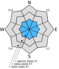
Human triggered avalanches remain possible on steep slopes above 6000 feet where the hazard is MODERATE. Assess the snow pack for layers of weak snow 1.5-3 feet deep, and choose conservative terrain where it exists and proves reactive. Below 6000 feet the hazard is LOW. Normal caution should be exercised while traveling in the backcountry like carrying your avalanche rescue gear and only exposing one person at a time to avalanche terrain.

2. Moderate
?
Above 6500 ft.
1. Low
?
5000-6500 ft.
1. Low
?
3500-5000 ft.
- 1. Low
- 2. Moderate
- 3. Considerable
- 4. High
- 5. Extreme
-
Type ?
-
Aspect/Elevation ?

-
Likelihood ?CertainVery LikelyLikelyPossible
 Unlikely
 -
Size ?HistoricVery LargeLargeSmall

The persistent slab problem is tricky due to the fact that it is only proving reactive in isolated areas. The culprits of this instability are layers weak snow in the form of facets or buried surface hoar formed in mid-December and mid-January that range from 1.5-3 feet deep. In other spots these layers are hard to identify or have gained strength and do not fail. The odds are pretty good that you will not trigger one of these slabs, but the consequence is too high to gamble on a slope with out first investigating the problem. In places where you find these persistent weak layers to be reactive, choose conservative, low angle terrain free of shallow rocky spots and steep convex roll-overs.
The next scheduled advisory will be Tuesday, February 3, 2015.
Yesterday we traveled in the Skyland area in the Flathead Range. At Lower elevations and on sunny aspects the thick melt-freeze crust supported the weight of our snowmobiles. Once again, stability tests produced variable results in multiple snow pits in the area. The pesky layer of weak snow formed in mid-December (2-3 feet deep in this area) propagated a fracture in some tests and in other locations was difficult to identify (photo).
Erich was with a level 1 class on Hellroaring Peak in the Whitefish Range yesterday. He also noted a firm melt-freeze crust with large surface hoar on top. On Wednesday, he observed instability associated with weak faceted snow and buried surface hoar from mid-January and mid-December in the Marion Lake area in the Flathead Range (video).
There have been multiple observations from all ranges in the advisory area that report large surface hoar development. It's worth noting the distribution of this layer, with more snow in the forecast it may soon be buried and present a problem in the future.
In the past 24 hours arctic air spilled over the Continental Divide and temperatures in the region dropped substantially. Currently, mountain stations report temperatures ranging from 5º-22ºF with winds out of the west/southwest 3-5 mph. Today will be mostly cloudy with temperatures reaching the mid to upper-20s. Light snow moves into the area in the afternoon with little accumulation expected until tonight. Winds will blow out of the west and southwest 5-10 mph with stronger gusts on the ridgetops.
| 0600 temperature: | 5-22 deg. F. |
| Max. temperature in the last 24 hours: | 13-28 deg. F. |
| Average wind direction during the last 24 hours: | N/NE |
| Average wind speed during the last 24 hours: | 5-10 mph |
| Maximum wind gust in the last 24 hours: | 15-20 mph |
| New snowfall in the last 24 hours: | 0-1 inches |
| Total snow depth: | 54-86 inches |
This advisory applies only to backcountry areas outside established ski area boundaries. This advisory describes general avalanche conditions and local variations always occur. This advisory expires at midnight on the posted day unless otherwise noted. The information in this advisory is provided by the USDA Forest Service who is solely responsible for its content.


