| Saturday | Saturday Night | Sunday | |
|---|---|---|---|
| Cloud Cover: | Cooler temperatures, light snow showers | Partly cloudy, continued cooling | Mostly cloudy, light snow |
| Temperatures: | 24-33 deg. F. | 9-20 deg. F. | 27-34 deg. F. |
| Wind Direction: | NE/NW | E/NE | S/SW |
| Wind Speed: | 5-6 | 6-7 | 5-6 |
| Snowfall: | 0-2 in. | 0 in. | 1-2 in. |
| Snow Line: |
Whitefish Range
Swan Range
Flathead Range and Glacier National Park
How to read the forecast
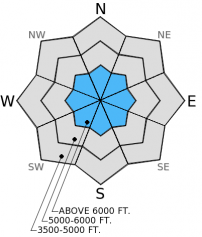
The avalanche hazard is MODERATE on steep slopes above 6000 feet for the lingering possibility of triggering 1.5-3 foot thick persistent slabs. Dig into the snow and look for these layers and see if they are reactive to stability tests. Below 6000 feet the hazard is LOW. Remember that Low hazard does not mean no hazard. Continue to practice safe back country travel technique and perform site specific snow pack assessment.

2. Moderate
?
Above 6500 ft.
1. Low
?
5000-6500 ft.
1. Low
?
3500-5000 ft.
- 1. Low
- 2. Moderate
- 3. Considerable
- 4. High
- 5. Extreme
-
Type ?
-
Aspect/Elevation ?

-
Likelihood ?CertainVery LikelyLikelyPossible
 Unlikely
 -
Size ?HistoricVery LargeLargeSmall

Now that temperatures have dropped below freezing we are unlikely to see natural avalanche activity associated with persistent slab. However, due to varying reactivity in stability tests across the area, buried suface hoar and weak snow formed in mid-January and even mid-December still warrant careful assessment. These weak layers are buried 1.5-4 feet deep and the only way to be sure of there existence and sensitivity is to dig into the snow and look for them. Where these layers are present and prove reactive, choose low angle terrain and avoid steep roll-overs, rocky areas, and older wind drifts.
If you like skiing or riding on crust, you're in luck. Yesterday we were in the Ghoulie Point area in the Whitefish Range and traveled on top of a firm melt-freeze crust with large surface hoar developing in most locations (photo). We found weak snow almost 2 feet deep formed in mid-Janurary, stability tests revealed fractures in this layer that did not propagate.
Seth was in Noisy Basin in the Swan Range yesterday and also noted large surface hoar formation on top of the recent melt-freeze crust. They identified weak snow buried 1-2 feet deep above the mid-January crust in several profiles, but found it to be unreactive in stability tests.
On Wednesday, Erich observed instability associated with weak faceted snow and buried surface hoar from mid-December and mid-January in the Marion Lake area in the Flathead Range (photo,video).
Skiers in the Essex Creek drainage in the Flathead Range observed large surface hoar developing on top of the melt-freeze crust (observation).
Temperatures have dropped over the past couple of days to a more appropriate level for January. As of 4:00 a.m. mountain temperatures range from 13º-28º F with winds out of the southwest at 6-9 mph and gusts to 15 mph. For today, expect partly/mostly cloudy skies with light snow showers. Temperatures will be in the mid-20s with light wind (5-10 mph) out of the southwest shifting to northeast.
| 0600 temperature: | 13-28 deg. F. |
| Max. temperature in the last 24 hours: | 29-33 deg. F. |
| Average wind direction during the last 24 hours: | SW |
| Average wind speed during the last 24 hours: | 3-7 mph |
| Maximum wind gust in the last 24 hours: | 16-20 mph |
| New snowfall in the last 24 hours: | 0-1 inches |
| Total snow depth: | 54-86 inches |
This advisory applies only to backcountry areas outside established ski area boundaries. This advisory describes general avalanche conditions and local variations always occur. This advisory expires at midnight on the posted day unless otherwise noted. The information in this advisory is provided by the USDA Forest Service who is solely responsible for its content.


