| Saturday | Saturday Night | Sunday | |
|---|---|---|---|
| Cloud Cover: | Mostly cloudy, warming temperatures and light snow/rain. | Light snow/rain | Showers tapering, becoming partly cloudy with rising temperatures |
| Temperatures: | 37-43 deg. F. | 32-39 deg. F. | 42-49 deg. F. |
| Wind Direction: | W/SW | W/SW | SW |
| Wind Speed: | 10-20 gusts 28-36 | 10-15 gusts 28-36 | 10-20 gusts 24-39 |
| Snowfall: | 0-2 in. | 0-1 in. | 0 in. |
| Snow Line: |
Whitefish Range
Swan Range
Flathead Range and Glacier National Park
How to read the forecast
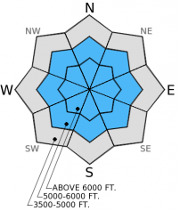
New wet, heavy snow overnight accompanied by rising temperatures and strong wind gusts created unstable conditions. The hazard above 5000 feet is rated CONSIDERABLE on slopes steeper than 35º. Human triggered storm slab avalanches are likely in steep terrain. Storm slab avalanches also have the potential to step down into deeper persistent slabs. Careful snow pack evaluation and conservative decision making are essential today.

3. Considerable
?
Above 6500 ft.
3. Considerable
?
5000-6500 ft.
2. Moderate
?
3500-5000 ft.
- 1. Low
- 2. Moderate
- 3. Considerable
- 4. High
- 5. Extreme
-
Type ?
-
Aspect/Elevation ?

-
Likelihood ?CertainVery LikelyLikelyPossible
 Unlikely
 -
Size ?HistoricVery LargeLargeSmall

Its a mixed bag across the area in regard to persistent slab. Even though the last reported avalanche in the region associated with weak snow near the mid-December crust was over 2 weeks ago, we continue to find areas where this layer is still reactive to stability tests. Now, we have another layer of surface hoar formed earlier this month that is buried between 1-1.5 feet deep. This layer has had varying reactivity across the advisory area, but is present in most locations. It still warrants careful evaluation, particularly as the additional weight of today may cause this weak layer to become more reactive. With changing weather conditions it is increasingly important to dig into the snow and see what's going on beneath you before commiting to any slope.
-
Type ?
-
Aspect/Elevation ?

-
Likelihood ?CertainVery LikelyLikelyPossible
 Unlikely
 -
Size ?HistoricVery LargeLargeSmall

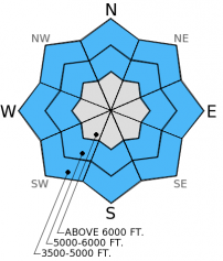
We did not pick up a lot of snow overnight, but it's wet, heavy nature and with the snow surfaces that it fell on ranging from hard wind slabs to surface hoar, it should be treated as suspect until proven innocent. Check the sensitivity of the storm snow by digging into the snowpack and stick to lower angle slopes before venturing onto steeper slopes.
-
Type ?
-
Aspect/Elevation ?

-
Likelihood ?CertainVery LikelyLikelyPossible
 Unlikely
 -
Size ?HistoricVery LargeLargeSmall

With the new wet, heavy snow and rain on snow at low to mid elevations pay close attention to loose, wet avalanches. Even small wet avalanches can be very dangerous in exposed terrain like cliff bands and terrain traps like gullies and creek beds.
We only received one report of glide avalanche activity earlier in the week, but it could serve as an indicator that we could begin to see more of these. As temperatures rise over the next few days, particularly if we get rain on snow or prolonged sun expose pay attention to areas where glide cracks begin to open and avoid slopes where they are present. Another problem that could arise with warmer temperatures on the horizon is cornices that become sensitive. Give them a wide buffer when traveling above or below them.
Yesterday in the Pinnacle drainage in the Flathead Range we observed some wind loading along the ridge lines (photo). In this location we did not find a preserved buried surface hoar in the upper snow pack or near the surface. Instead we found quite a bit of graupel (photo). In a pit dug in a relatively shallow area we were able to propagate a fracture with hard force in extended column tests in the mid-December surface hoar layer about 1.5 feet deep (photo).
Yesterday, Erich was in the Ghoulie Point area oustide the Whitefish Mountain Resort boundary in the southern Whitefish Range. He found surface hoar buried by 1-2 inches of new snow. He also noted surface hoar a little over a foot deep that fractured in stability tests but did not propagate that fracture.
On Thursday, skiers on Essex Mountain in the Flathead Range observed similar layers of weak snow in the snow pack (observation).
Skiers in the "Big Slide" area in the southern Whitefish Range reported triggering a small, hard wind slab avalanche in sub-alpine terrain on Wednesday.
In the past 24 hours we received 1-7 inches of wet, heavy snow. Since the onset of continued precipitation SNOTEL sites recorded 0.6-1.3 inches of snow water equivalent. Winds have averaged 5-15 mph out of the southwest with gusts up to 30 mph and temperatures have been steadily climbing to the wrong side of freezing. Currently, temperatures range from 31º-36º F and winds continue out of the southwest at 5-15 mph, increasing near the divide. For today mountain temperatures are expected to reach the mid to high 30s, snow/rain should taper this morning and become light showers before increasing later this evening. West and southwest winds will continue today at 10-20 mph with strong gusts on the ridges.
| 0600 temperature: | 30-36 deg. F. |
| Max. temperature in the last 24 hours: | 30-36 deg. F. |
| Average wind direction during the last 24 hours: | SW |
| Average wind speed during the last 24 hours: | 5-15 mph |
| Maximum wind gust in the last 24 hours: | 10-30 mph |
| New snowfall in the last 24 hours: | 1-7 inches |
| Total snow depth: | 59-93 inches |
This advisory applies only to backcountry areas outside established ski area boundaries. This advisory describes general avalanche conditions and local variations always occur. This advisory expires at midnight on the posted day unless otherwise noted. The information in this advisory is provided by the USDA Forest Service who is solely responsible for its content.


