| Tuesday | Tuesday Night | Wednesday | |
|---|---|---|---|
| Cloud Cover: | Lingering showers in the morning with clearing and drying by mid-day. | Partly cloudy. | Partly cloudy to mostly clear. |
| Temperatures: | 25-32 deg. F. | 11-20 deg. F. | 24-31 deg. F. |
| Wind Direction: | West | West-Southwest | Southwest |
| Wind Speed: | 5-10 mph | 1-5 mph | 4-8 mph with gusts to 16 mph. |
| Snowfall: | 0 in. | 0 in. | 0 in. |
| Snow Line: |
Whitefish Range
Swan Range
Flathead Range and Glacier National Park
How to read the forecast
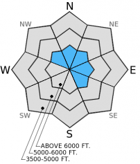
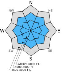
The avalanche hazard today is CONSIDERABLE on wind loaded slopes and slopes steeper than 35 degrees above 6000 feet and MODERATE on all other terrain. Strong winds and recent snow over the past 72 hours created wind slabs that are still sensitive to human triggering. A layer of surface hoar within the top 12-16 inches of the snowpack as well as another layer buried more deeply (3-4 feet) make it possible to trigger an avalanche on non-wind loaded slopes today.

3. Considerable
?
Above 6500 ft.
2. Moderate
?
5000-6500 ft.
2. Moderate
?
3500-5000 ft.
- 1. Low
- 2. Moderate
- 3. Considerable
- 4. High
- 5. Extreme
-
Type ?
-
Aspect/Elevation ?

-
Likelihood ?CertainVery LikelyLikelyPossible
 Unlikely
 -
Size ?HistoricVery LargeLargeSmall

Moderate to strong winds over the past four days combined with up to a foot of new snow in some locations created widespread wind slabs. These slabs formed on a vareity of surfaces including facets and surface hoar. These wind slabs remain sensitive and it is likely you will trigger a wind slab today on wind loaded or cross-loaded slopes. Look for wind loaded terrain at upper elevations where slopes were cross-loaded and wind slabs formed on or near features like gulley walls, tree islands, and rock bands. Avoid slopes where the snow surface looks smooth or rounded and the wind created pillows that appear thicker than other areas.
-
Type ?
-
Aspect/Elevation ?

-
Likelihood ?CertainVery LikelyLikelyPossible
 Unlikely
 -
Size ?HistoricVery LargeLargeSmall

The surface hoar sitting above a melt-freeze crust from mid-December still remains a concern. This layer now sits about 3-5 feet deep from the surface throughout the advisory area. As of three days ago this layer still had the propensity to propagate fractures in extended column tests, but we have not heard reports of avalanches involving this layer in over 2 weeks. However, it is still possible to trigger an avalanche on this layer. Avoid steep, rocky areas with a shallow snowpack where this layer is closer to the surface and more easily triggered.
We also now have a layer of surface hoar and facets that formed last week buried within the top foot of the snowpack. This layer may not be as widespread or developed as the deeper layer, but, until we get a handle on its distribution and sensitivity, treat it with caution. Both of these layers require one to dig down into the snow and peform a stability test to assess their presence and reactivity. This should only take a few minutes and is a very valuable piece of information.
The next regularly scheduled advisory will be issued Thursday, Jan. 22, 2015
Join the Flathead Avalanche Center and Friend of the Flathead Avalanche Center tonight at The White Room in Whitefish at 6:30 pm for a Ladies Avalanche Awareness Night! More info here.
The wind sensor at the Big Mountain Summit weather station is still being repaired. We hope to have it back online within the next week. Thanks for your patience.
Your observations are extremely valuable to us! Let us know what you are seeing in the backcountry. Here is a good article written by our colleagues at the Gallatin National Forest Avalanche Center that discusses why avalanches should be reported.
The storm with strong winds over the weekend produced a fairly widespread natural avalanche cycle with avalanches up to size D2. We observed numerous avalanches on all aspects on mid and upper elevation slopes in the Lost Johnny drainage in the Swan Range yesterday (photo 1, photo 2). We also observed sensitive wind slabs on leeward slopes (photo) that are still prone to human triggering. BNSF Avalanche Safety also observed several small (D1-D2) natural avalanches in John F. Stevens Canyon in southern Glacier Park within the past 48 hours.
A layer of facets and surface hoar that formed last week exists within the top 12-16 inches of the snowpack (snow profile). This layer has not yet propagated fractures in our stability tests in the Swan Range yesterday, but others found layers at a similar depth to propagate fractures in the Middle Fork corridor of the Flathead Range (observation).
Lingering snow showers this morning will give way to clearing and drying conditions over the next few days in the mountains. As of 4:00 a.m., remote mountain stations report temperatures from 18º to 24º F with winds moving out of the southwest at 5-10 mph and gusting to 15 mph. Up to an inch of new snow fell yesterday in most locations. Today, temperatures will be in the mid 20s to low 30s F with winds moving out of the west at 5-10 with gusts to 25 mph this afternoon, particularly closer to the Continental Divide.
| 0600 temperature: | 18-24 deg. F. |
| Max. temperature in the last 24 hours: | 24-29 deg. F. |
| Average wind direction during the last 24 hours: | Southwest |
| Average wind speed during the last 24 hours: | 5-10 mph |
| Maximum wind gust in the last 24 hours: | 29 mph |
| New snowfall in the last 24 hours: | 1 inches |
| Total snow depth: | 60-92 inches |
This advisory applies only to backcountry areas outside established ski area boundaries. This advisory describes general avalanche conditions and local variations always occur. This advisory expires at midnight on the posted day unless otherwise noted. The information in this advisory is provided by the USDA Forest Service who is solely responsible for its content.


