| Sunday | Sunday Night | Monday | |
|---|---|---|---|
| Cloud Cover: | Snow/Rain with rising snow levels. | Lighter snow showers with lowering snow levels | Mostly cloudy, cooler temperatures, light snow showers |
| Temperatures: | 35-43 deg. F. | 26-31 deg. F. | 29-36 deg. F. |
| Wind Direction: | SW | W/SW | W/SW |
| Wind Speed: | 18-29 gusts 40-63 | 16-24 gusts 32-56 | 13-20 gusts 31-40 |
| Snowfall: | 5-9 in. | 2-6 in. | 1-4 in. |
| Snow Line: |
Whitefish Range
Swan Range
Flathead Range and Glacier National Park
How to read the forecast
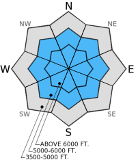
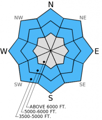
With continued strong, gusty winds and new snow to add depth to unstable wind slabs, the avalanche hazard is HIGH on wind loaded slopes above 5000 feet. Wind loaded terrain at mid to upper elevations and all run-out zones should be avoided. On non-wind loaded slopes the hazard is CONSIDERABLE due to storm slab formation on a weak snow surface and loose, wet avalanche hazard at low elevation. Careful snow pack evaluation and conservative decision making are essential today.

4. High
?
Above 6500 ft.
4. High
?
5000-6500 ft.
3. Considerable
?
3500-5000 ft.
- 1. Low
- 2. Moderate
- 3. Considerable
- 4. High
- 5. Extreme
-
Type ?
-
Aspect/Elevation ?

-
Likelihood ?CertainVery LikelyLikelyPossible
 Unlikely
 -
Size ?HistoricVery LargeLargeSmall

Moderate to strong west and southwest winds over the past few days and substantial recent snow with rising temperatures created unstable conditions. Sensitive wind slabs were observed across the area on Friday and Saturday, the only thing that has changed since then are increased wind speed and more snow. In some locations wind slabs were formed on weak snow surfaces and will take longer than usual to gain strength. We will likely see natural avalanche activity on upper elevation wind loaded slopes today. It is recommended that you avoid wind loaded terrain and equally important to avoid run-out zones. Keep in mind that wind often drifts the snow into sneaky areas, identifying wind loaded terrain is not always as easy as simply avoiding leeward ridges. Watch for cross-loaded slopes at mid-elevations near terrain features that can slow the wind and catch the snow. Rising temperatures during the snow fall last night likely created an upside down storm slab in the low to mid-elevations. This storm slab could cause the weak layers formed in early January to become reactive. Careful evaluation of the storm snow instability is essential today.
-
Type ?
-
Aspect/Elevation ?

-
Likelihood ?CertainVery LikelyLikelyPossible
 Unlikely
 -
Size ?HistoricVery LargeLargeSmall

As the temperature rises this morning so will the loose, wet avalanche hazard particularly at the lower elevations. If the snow surface becomes wet or if snow turns to rain avoid any steep terrain and terrain traps. Remember that even small avalanches can have severe consequences if traveling in exposed areas like cliff bands, in the trees, and narrow gulleys.
-
Type ?
-
Aspect/Elevation ?

-
Likelihood ?CertainVery LikelyLikelyPossible
 Unlikely
 -
Size ?HistoricVery LargeLargeSmall

It seems as though the weak snow near the mid-December crust that is buried between 2-3 feet deep is becoming more reactive. These weak layers became comfortable with the load deposited in the last substantial storm and now the recent snow is once again stressing these layers. For several weeks there were no observed failures in stability tests or reported avalanche activity associated with the persistent slab. Triggering this layer remains difficult because of it's depth, however recent observations illustrate that it is still possible. Though unlikely, consider the consequence of triggering a deep slab, the resulting avalanche would be very large and destructive. Carefully evaluate each slope you intend to ski or ride for the reactivity of the persistent slab. Remember that in our current active weather pattern we are adding stress to snow pack, so if you were on a slope two weeks ago, don't assume stability related to the persistent slab today.
The next scheduled advisory will be Tuesday, January 20, 2015.
Yesterday we rode to Werner Peak in the southern Whitefish Range. In areas where the 6 inches of recent snow was not wind affected it was low density and unconsolidated with well preserved surface hoar and faceted snow beneath it. These weak layers warrant careful evaluation as a cohesive slab develops above them. We dug into several short, low angle, wind loaded slopes and found this weak snow still preserved and with more cause for concern with the overlying slab. It took easy force (ECTP5) in extended column tests to propagate a fracture in the 12-15 inch wind slabs (photo). We tested another short, low angle, wind loaded slope by riding above it which produced cracking and failure of the wind slab (photo). These exposed ridgelines seemed like an unlikely spot to harbor buried surface hoar. After going weeks with out a failure in the deeply buried surface hoar from mid-December, it failed with propagation in some locations. In this area it was buried almost 3 feet deep and took hard force to trigger.
BNSF Avalanche Safety reported a natural cornice failure in their program area, the cornice did not trigger anything below, but is a good sign that a substantial amount of snow is being transported on the ridges.
Skiers in the Crystal Creek drainage in the Flathead Range yesterday reported sensitive wind slabs. The party unintentionally triggered a 12 inch thick slab that ran nearly to the bottom of the drainage. They also found the surface hoar layer that was buried in mid-December to be reactive in stability tests. This layer propagated a fracture 2.5 feet deep in extended column test with hard force (ECTP 25). They also noted that the bed surfaces from avalanches that occured during the early January cycle (likely mid-december crust) had filled in with wind drifted snow and were also reactive.
Ridge top winds for the past several days averaged between 10-20 mph out of the west and southwest with gusts in the 30-50 mph range. Overnight we picked up another 4-10 inches of new snow with a gradual rise in temperature. Snow water equivalents recorded in the last 6 hours range from 0.3 to 0.9 inches. Currently, mountain temperatures range from 24º-31º F with winds out the southwest 10-15 mph and gusts to 28 mph. For today winds will continue out of the west and southwest 15-25 mph. Snow levels are expected to rise to about 4000 feet and then begin to fall around mid-day as snow becomes more showery.
| 0600 temperature: | 23-31 deg. F. |
| Max. temperature in the last 24 hours: | 24-31 deg. F. |
| Average wind direction during the last 24 hours: | SW |
| Average wind speed during the last 24 hours: | 10-20 mph |
| Maximum wind gust in the last 24 hours: | 28-52 mph |
| New snowfall in the last 24 hours: | 3-5 inches |
| Total snow depth: | 60-92 inches |
This advisory applies only to backcountry areas outside established ski area boundaries. This advisory describes general avalanche conditions and local variations always occur. This advisory expires at midnight on the posted day unless otherwise noted. The information in this advisory is provided by the USDA Forest Service who is solely responsible for its content.


