| Saturday | Saturday Night | Sunday | |
|---|---|---|---|
| Cloud Cover: | Partly/Mostly cloudy continued strong wind gusts | Heavy precipitation with rising snow levels | Warmer temperatures, continued rain/snow |
| Temperatures: | 29-37 deg. F. | 27-33 deg. F. | 37-44 deg. F. |
| Wind Direction: | southwest | south/southwest | southwest |
| Wind Speed: | 10-15 gusts 21-32 | 9-16 gusts 23-36 | 18-25 gusts 40-45 |
| Snowfall: | 0.00 in. | 3-12 in. | 5-10 in. |
| Snow Line: |
Whitefish Range
Swan Range
Flathead Range and Glacier National Park
How to read the forecast
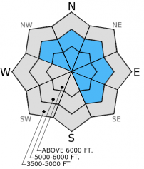
Strong, gusty winds continue to drift snow and create sensitive wind slabs. The avalanche hazard is CONSIDERABLE on wind loaded slopes above 5000 feet and MODERATE below 5000 feet. The possibility of triggering a persistent slab avalanche remains, particularly in areas near the divide where buried surface hoar is preserved in the snowpack. Stick to slopes that are sheltered from the wind, and carefully evaluate the snow pack for deeper instabilities.

3. Considerable
?
Above 6500 ft.
3. Considerable
?
5000-6500 ft.
2. Moderate
?
3500-5000 ft.
- 1. Low
- 2. Moderate
- 3. Considerable
- 4. High
- 5. Extreme
-
Type ?
-
Aspect/Elevation ?

-
Likelihood ?CertainVery LikelyLikelyPossible
 Unlikely
 -
Size ?HistoricVery LargeLargeSmall

Strong, gusty west and southwest winds created sensitive wind slabs in the past 24 hours. In many areas these new slabs formed on weak snow surfaces adding to their instability. Moderate to strong winds will continue to drift snow today and add depth to these slabs. Stick to the slopes sheltered from the wind today. Look for wind loaded terrain in the mid-elevations where slopes were cross-loaded and wind slabs formed on or near features like gulley walls, tree islands, and rock bands. Be aware of slopes where the snow surface looks smooth or rounded and the wind created pillows that appear thicker than other areas.
-
Type ?
-
Aspect/Elevation ?

-
Likelihood ?CertainVery LikelyLikelyPossible
 Unlikely
 -
Size ?HistoricVery LargeLargeSmall

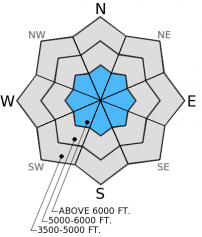
The buried surface hoar and facets near the mid-December crust still exists in most areas but is only a problem in isolated areas, particularly as you approach the divide. Continue to assess the snow pack in the areas you ski or ride by digging down and looking for this weak snow and check how reactive the layer is by performing a stability test like an extended column test (video). In areas that this layer still proves reactive, the problem is best managed by sticking to low angle slopes and simple terrain.
Though we are expected to stay below freezing today at higher elevations, we are in a warming trend. Be aware of changing conditions, particularly at low to mid elevations. Watch for new roller ball activity which is a good indication that loose, wet avalanche hazard is on the rise.
Remember that weak snow near the early January crust? As snow continues to pile up ontop of surface hoar and near-surface facets be aware of a slab forming within recent snow, even in non-wind loaded areas. Where a cohesive slab has formed, be sure to assess the reactivity of the new slab.
Yesterday, Erich was in the John F Stevens Canyon in the Lewis Range and observed active wind loading of east slopes that created sensitive wind slabs (photo, video). He also noted a well preserved layer of buried surface hoar about 3 feet deep that propagated a fracture with hard force in multiple extended column tests (photo).
FAC snowmobile observers were in the 6-mile area in the Swan Range yesterday. They also saw active wind drifting in this area and found fresh wind slabs that were less reactive than observed in the Middle Fork, but slope tests on short, unexposed terrain showed the ability to propagate a fracture in these new wind slabs.
BNSF Avalanche Safety was in John F Stevens Canyon on Thursday and observed weak snow in the mid-snow pack, but stability tests showed more stable results than Erich noted yesterday in a nearby area (observation). This illustrates the importance of doing a site specific snow pack evaluation in the area that you are skiing or riding.
Yesterday the snow returned to the area after a few dry, high pressure days. We picked up between 2-5 inches of snow, the bulk of which fell in the Flathead Range and Glacier National Park. Winds also ramped up in the last 24 hours, only averaging 5-15 mph out of the west and southwest, but gusts ranging from 36 to 46 mph. Currently, mountain temperatures range from 19º-25º F and winds are 10-15 mph out of the southwest. Temperatures are expected to remain in the high-20s to low-30s today with strong, gusty winds continuing on the ridges. Snow should resume late afternoon/early evening and continue through the night with warming temperatures and rising snow levels.
| 0600 temperature: | 19-25 deg. F. |
| Max. temperature in the last 24 hours: | 24-30 deg. F. |
| Average wind direction during the last 24 hours: | SW |
| Average wind speed during the last 24 hours: | 5-15 mph |
| Maximum wind gust in the last 24 hours: | 17-36 mph |
| New snowfall in the last 24 hours: | 2-5 inches |
| Total snow depth: | 59-88 inches |
This advisory applies only to backcountry areas outside established ski area boundaries. This advisory describes general avalanche conditions and local variations always occur. This advisory expires at midnight on the posted day unless otherwise noted. The information in this advisory is provided by the USDA Forest Service who is solely responsible for its content.


