| Thursday | Thursday Night | Friday | |
|---|---|---|---|
| Cloud Cover: | Partly cloudy and dry conditions. Increasing winds this afternoon. | Cloudy with snow starting overnight. Increasing to strong winds. | Snow and strong winds. Rising temperatures. |
| Temperatures: | 26-38 deg. F. | 23-28 deg. F. | 32-39 deg. F. |
| Wind Direction: | Southwest | Southwest | Southwest |
| Wind Speed: | 5-10 mph with gusts to 25 mph. | 10-20 mph with gusts to 36 mph. | 15-25 mph with gusts to 45 mph. |
| Snowfall: | 0 in. | 0-1 in. | 2-4 in. |
| Snow Line: |
Whitefish Range
Swan Range
Flathead Range and Glacier National Park
How to read the forecast
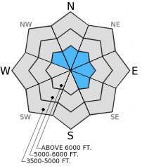
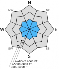
The avalanche hazard is MODERATE above 5000 ft. on wind loaded slopes and slopes steeper than 35 degrees. All other slopes have a LOW hazard. Fresh wind slabs and a persistent weak layer in isolated locations make it possible to trigger an avalanche today. Shallow wind slabs exist at upper elevations due to moderate winds yesterday. In areas with a more shallow snowpack the surface hoar from mid-December still exists. Evaluate snow and terrain carefully and identify features of concern.

2. Moderate
?
Above 6500 ft.
2. Moderate
?
5000-6500 ft.
1. Low
?
3500-5000 ft.
- 1. Low
- 2. Moderate
- 3. Considerable
- 4. High
- 5. Extreme
-
Type ?
-
Aspect/Elevation ?

-
Likelihood ?CertainVery LikelyLikelyPossible
 Unlikely
 -
Size ?HistoricVery LargeLargeSmall

West-southwest winds increased throughout the day yesterday and we observed active wind loading on slopes near ridgetops. Above the rain crust there is ample light snow for wind transport. Expect wind slabs to become more cohesive and get larger as winds increase today and tonight ahead of an approaching storm. Pay attention to these increasing winds particularly in areas near the Continental Divide (like Marias Pass) where wind slabs could be thicker, easier to trigger, and more widespread. Identify wind loaded slopes and dig down into the surface snow to determine the thickness and reactivity of these slabs.
-
Type ?
-
Aspect/Elevation ?

-
Likelihood ?CertainVery LikelyLikelyPossible
 Unlikely
 -
Size ?HistoricVery LargeLargeSmall

The surface hoar and facets above the melt-freeze crust from mid-December still persist in isolated locations. As mentioned, in most locations throughout the advisory area this layer has gained strength and has not been reactive in stability tests for quite a while. While this layer may be isolated to areas with a more shallow snowpack where it is closer to the surface it goes to show that it is still persistent and still possible to trigger an avalanche on this layer. The only way to diagnose this problem is to dig into the snow. Verify if this layer exists and, if so, determine how reactive it is by performing stability test like an extended column test (ECT) (video). It shouldn't take that long and is well worth the time. Avoid this problem by sticking to simple, less steep terrain (slopes less than about 35 degrees).
Due to existing inversions over the region the mountains will warm quicker than the valleys today. If temperatures reach above freezing with ample solar input, we could begin to see small loose, wet sluffs at the mid- and even upper elevations on sunny aspects. Pay attention to warming temperatures and watch for rollerballs on sunny aspects - a good indicator that conditions are changing.
The next regularly scheduled advisory will be issued Saturday, January 17, 2015.
Check out our education page for upcoming avalanche awareness classes. Tonight, 1/15/2015, 6:30 pm - Avalanche Awareness, Sportsmans & Ski Haus, Whitefish1/20/2015, 6:30 pm - Ladies Avalanche Awareness, The White Room, Whitefish
The wind sensor at Big Mountain Summit weather station is offline and being repaired so all current wind values are invalid. We'll let you know as soon as it goes back online.
Yesterday, we dug numerous snow pits in the Skyland area near Marias Pass in the Flathead Range. We found the rain crust from Jan. 6 up to around 6000 ft. We were also surprised to find that well preserved surface hoar still exists about 2-3 feet below the surface in this area (video). In most locations throughout our advisory area this layer has flattened, gained strength, and has not been reactive in stability tests for about two weeks. Yesterday, however, this layer was able to propagate fractures in some of our extended column tests with moderate to hard force (snow profile). We also found weak snow near the surface that is something to watch our for as the next storm approaches.
We observed lingering hard wind slabs at upper elevations a few inches below the surface and fresh wind slabs near the surface. These wind slabs were fairly thin, but winds were increasing throughout the day yesterday. Other skiing parties in the Middle Fork area reported light surface snow being deposited on leeward slopes and slightly reactive wind slabs at the surface.
BNSF Avalanche Safety reported facets underneath the rain crust near the surface. This layer was reactive in their stability tests on Tuesday, but currently lacks a slab above it. They also observed strengthening of persistent weak layers deeper in the snowpack at their location.
A ridge of high pressure continues over the region today bringing warmer mountain temperatures and dry conditions. Mountain weather stations report temperatures ranging from 12º to 32º F with winds moving out of the southwest at 5-10 mph and gusts to 15 mph. Today, temperatures will range from 25º-38º F and winds will increase throughout the day to 10-15 mph with gusts to 30 mph out of the southwest. Areas closer to the Continental Divide (like Marias Pass) could see gustier winds. The ridge breaks down tonight as a moist system enters the region bringing strong winds and snow.
| 0600 temperature: | 17-26 deg. F. |
| Max. temperature in the last 24 hours: | 26 deg. F. |
| Average wind direction during the last 24 hours: | Southwest |
| Average wind speed during the last 24 hours: | 5-10 mph |
| Maximum wind gust in the last 24 hours: | 21 mph |
| New snowfall in the last 24 hours: | 0 inches |
| Total snow depth: | 58-89 inches |
This advisory applies only to backcountry areas outside established ski area boundaries. This advisory describes general avalanche conditions and local variations always occur. This advisory expires at midnight on the posted day unless otherwise noted. The information in this advisory is provided by the USDA Forest Service who is solely responsible for its content.


