| Wednesday | Wednesday Night | Thursday | |
|---|---|---|---|
| Cloud Cover: | Partly cloudy. | Partly cloudy. | Partly cloudy. |
| Temperatures: | 27-33 deg. F. | 12-21 deg. F. | 24-32 deg. F. |
| Wind Direction: | West-Southwest | Southwest | Southwest |
| Wind Speed: | 5-10 mph with gusts to 25 mph. | 5-10 mph with gusts to 20 mph. | 5-15 mph with gusts to 20 mph. |
| Snowfall: | 0 in. | 0 in. | 0 in. |
| Snow Line: |
Whitefish Range
Swan Range
Flathead Range and Glacier National Park
How to read the forecast
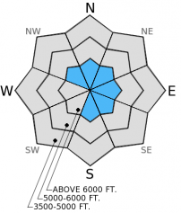
The avalanche hazard today is MODERATE on wind loaded slopes steeper than 35 degrees. All other slopes have a LOW hazard. Watch for unstable snow on isolated terrain features like wind loaded slopes or steep, rocky areas with a more shallow snowpack. Continue to practice safe travel techniques by traveling one at a time on a slope and always carry your avalanche safety gear.

2. Moderate
?
Above 6500 ft.
1. Low
?
5000-6500 ft.
1. Low
?
3500-5000 ft.
- 1. Low
- 2. Moderate
- 3. Considerable
- 4. High
- 5. Extreme
-
Type ?
-
Aspect/Elevation ?

-
Likelihood ?CertainVery LikelyLikelyPossible
 Unlikely
 -
Size ?HistoricVery LargeLargeSmall

Lingering wind slabs may exist on wind loaded and cross loaded slopes at upper elevations. Some of these wind slabs could be hard and masked by a few inches of new snow from last Saturday. Typical pillowed, wind loaded slopes with a chalky look to them may be harder to identify due to this new snow sitting on top of these slabs. Assess each slope by digging into the snow to determine if a wind slab exists and avoid these isolated features of instability.
Practicing safe travel protocol in avalanche terrain is always important even during periods of Low hazard. Travel one at a time on slopes, keep your partner in sight, and remember that even small slides can have large consequences in steep, cliff areas or terrain traps. Continue to dig down into the snow and see what is going on because the snowpack could be developing the next weak layer. Also let us know what you are seeing out there. Your observations are always important to us even during periods of less activity.
The next regularly scheduled advisory will be issued Thursday, January 15, 2015.
Check out our education page for upcoming avalanche awareness classes. 1/15/2015, 6:30 pm - Avalanche Awareness, Sportsmans & Ski Haus, Whitefish1/20/2015, 6:30 pm - Ladies Avalanche Awareness, The White Room, Whitefish
The wind sensor at Big Mountain Summit weather station is offline and being repaired. We'll let you know as soon as it goes back online.
We are currently trying to assess both surface and near surface snowpack development as well as any lingering instabilities deeper in the snowpack. In the Red Meadow area in the northern Whitefish Range, we found a bit of surface hoar and near surface facets in the top part of the snowpack (image and video). This snow structure appears to be evident across the advisory area (image). While not a problem now, these layers could become problematic once a slab develops above them. We'll just have to wait and see. Lingering hard wind slabs exist but did not propagate fractures in our stability tests.
Stability test results show no propagation of any layers deeper in the snowpack. The facets above the melt-freeze crust from mid-December still exist, but appear to be gaining strength and are buried about 3.5 to 5 feet deep now. The surface hoar just above that has mostly flattened and rounded and is very difficult to identify in snowpits.
We received no new observations from the Swan Range or the Flathead Range/Glacier Park.
Mild weather will continue over the next 36 hours as a weak high pressure builds over the area. As of 4:00 am, mountain weather stations report temperatures of 14º-20º F with winds moving out of the southwest at 5-10 mph with gusts to 15 in the past 24 hours. For today, expect temperatures in the upper 20s F with west-southwest winds at 5-10 with gusts up to 25 mph. Mostly dry conditions should prevail through Thursday.
| 0600 temperature: | 14-20 deg. F. |
| Max. temperature in the last 24 hours: | 19-26 deg. F. |
| Average wind direction during the last 24 hours: | Southwest |
| Average wind speed during the last 24 hours: | 5-10 mph |
| Maximum wind gust in the last 24 hours: | 21 mph |
| New snowfall in the last 24 hours: | 0 inches |
| Total snow depth: | 58-90 inches |
This advisory applies only to backcountry areas outside established ski area boundaries. This advisory describes general avalanche conditions and local variations always occur. This advisory expires at midnight on the posted day unless otherwise noted. The information in this advisory is provided by the USDA Forest Service who is solely responsible for its content.


