| Saturday | Saturday Night | Sunday | |
|---|---|---|---|
| Cloud Cover: | Partly/Mostly cloudy, light snow in the afternoon | Increasing snow intensity | Continued light snow showers |
| Temperatures: | 24-31 deg. F. | 15-22 deg. F. | 24-30 deg. F. |
| Wind Direction: | SW | NW | E/NE |
| Wind Speed: | 5-7 | 3-6 | 3-6 |
| Snowfall: | 0-1 in. | 2-4 in. | 1-4 in. |
| Snow Line: |
Whitefish Range
Swan Range
Flathead Range and Glacier National Park
How to read the forecast
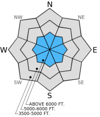
The potential exists to find lingering unstable wind slabs in isolated areas at high elevation. Since triggering an avalanche in this terrain remains possible, the hazard is MODERATE on wind-loaded slopes above 6000 feet. Cool temperatures following last week's warm storm and storm snow settlement decreased the hazard in terrain below 6000 feet where the hazard is LOW. Normal caution, site specific snow pack evaluation, and safe travel technique should still be excercised when traveling in the backcountry.

2. Moderate
?
Above 6500 ft.
1. Low
?
5000-6500 ft.
1. Low
?
3500-5000 ft.
- 1. Low
- 2. Moderate
- 3. Considerable
- 4. High
- 5. Extreme
-
Type ?
-
Aspect/Elevation ?

-
Likelihood ?CertainVery LikelyLikelyPossible
 Unlikely
 -
Size ?HistoricVery LargeLargeSmall

Recently formed wind slabs have had a few days to settle and strengthen, however site specific assessment and a cautious approach to wind loaded areas is still warranted. In isolated areas, particularly in steep terrain, unstable wind slabs exist. Remember that if you ski or ride on one slope without incident, assumptions should not be made about the stability on different slopes.
While it is no longer a widespread problem, deep persistent slabs still exist in the area. These slabs have undergone a very rigorous test with the substantial recent snow load. There are areas with weak snow now buried 3-6 feet deep, though unlikely to trigger such a slab, it is not impossible. Avoid areas where you increase the odds of triggering a deep slab like where you find weak snow closer to the surface and steep, convex roll-overs.
Yesterday in Noisy Basin in the Swan Range we traveled on top of a supportable rain crust up to 6300 feet. Above 6300 feet the crust was breakable and took on a more melt-freeze characteristic which was present to nearly 6500 feet. We found weak snow on or near the surface in most locations in the form of surface hoar or near surface facets. Good visibility allowed us to see substantial amounts of wind drifted snow on surrounding ridges and peaks (photo). We did not observe any obvious signs of instability associated with wind slabs, and extended column tests did not propagate a fracture in wind slabs tested. However, given the widespread nature of the recent wind event, each wind loaded area should still be treated as guilty until proven otherwise.
Skiers in the Wahoo/Rescue drainages in the Flathead Range on Thursday also found a rain crust up to 6500 feet (observation). Yesterday, skiers in the southern Whitefish Range noted a crust with surface hoar forming on top in some locations (observation).
The past 24 hours have been mostly dry with light southwest winds and temperatures topping out in the upper-20s. Currently, mountain temperatures range from 20º-27º F and winds are out the southwest 5-10 mph with gusts to 16 mph. For today, we should see partly/mostly cloudy skies with temperatures reaching the mid to upper-20s and 5-10 mph winds out of the west and southwest. Light snow moves into the area later in the day and increases in intensity tonight.
| 0600 temperature: | 20-27 deg. F. |
| Max. temperature in the last 24 hours: | 21-29 deg. F. |
| Average wind direction during the last 24 hours: | SW |
| Average wind speed during the last 24 hours: | 5-10 mph |
| Maximum wind gust in the last 24 hours: | 19-22 mph |
| New snowfall in the last 24 hours: | 0.00 inches |
| Total snow depth: | 70-90 inches |
This advisory applies only to backcountry areas outside established ski area boundaries. This advisory describes general avalanche conditions and local variations always occur. This advisory expires at midnight on the posted day unless otherwise noted. The information in this advisory is provided by the USDA Forest Service who is solely responsible for its content.


