| Thursday | Thursday Night | Friday | |
|---|---|---|---|
| Cloud Cover: | Partly to mostly cloudy with cold air moving in from the east. | Cold temps and high pressure building. | Cold air moves out. Partly to mostly cloudy. |
| Temperatures: | 15 to 22 deg. F. | -6 to 5 deg. F. | 21-33 deg. F. |
| Wind Direction: | East-Northeast | East-Northeast | South-Southeast |
| Wind Speed: | 5-15 mph gusting to 30 mph. | 5-15 gusting to 30 mph. | 3-5 mph gusts to 10 mph. |
| Snowfall: | 0 in. | 0-2 in. | 0 in. |
| Snow Line: |
Whitefish Range
Swan Range
Flathead Range and Glacier National Park
How to read the forecast
Recent moderate to strong winds created wind slabs on leeward and cross loaded slopes above 6500 feet. Lingering storm slabs may also exist on slopes steeper than 35 degrees. The avalanche hazard today is CONSIDERABLE on wind loaded slopes and MODERATE on all other slopes. Careful snowpack evaluation is essential today in identifying wind loaded slopes. It is also important to evaluate snow and terrain to assess the stability of recent storm snow.

3. Considerable
?
Above 6500 ft.
2. Moderate
?
5000-6500 ft.
2. Moderate
?
3500-5000 ft.
- 1. Low
- 2. Moderate
- 3. Considerable
- 4. High
- 5. Extreme
-
Type ?
-
Aspect/Elevation ?
-
Likelihood ?CertainVery LikelyLikelyPossible
 Unlikely
 -
Size ?HistoricVery LargeLargeSmall

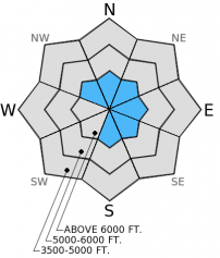
Moderate to strong winds into Wednesday formed fresh wind slabs above 6500 feet on leeward and cross loaded slopes. Above 6500 feet the rain crust doesn't exist and there is plenty of recent snow for the wind to move around. Wind slabs could be up to a foot thick on slopes near the tops of ridges. Pay attention to changing wind direction today. Winds were previously out of the southwest, but with north to northeast winds expected today wind loading patterns will change and we could see wind slabs on many aspects. Avoid wind loaded slopes today by carefully evaluating the snowpack and wind patterns.
-
Type ?
-
Aspect/Elevation ?
-
Likelihood ?CertainVery LikelyLikelyPossible
 Unlikely
 -
Size ?HistoricVery LargeLargeSmall

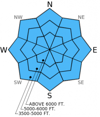
It may still be possible to trigger lingering storm slab avalanches on slopes greater than 35 degrees. Given the lack of recent observations from the Swan and Whitefish Ranges, our confidence is low about the sensitivity of storm slabs in those areas after the storm. Storm slabs could fail at the interface between the new and old snow or at any given density change within the recent snow. Allow time for the new snow to settle and carefully evaluate the snowpack. Also, let us know what you are seeing as you travel in the backcountry.
-
Type ?
-
Aspect/Elevation ?
-
Likelihood ?CertainVery LikelyLikelyPossible
 Unlikely
 -
Size ?HistoricVery LargeLargeSmall

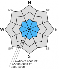
The persistent slab problem (surface hoar and facets above a melt-freeze crust) that we were dealing with for several weeks is buried deeply now (4-6 feet). Prior to this storm this surface hoar and facet layer was improving and showing very few signs of instabilty in stability tests. This storm was a good test, and I suspect that at least a few avalanches failed on this layer. Given that it is buried deeply now it is becoming more unlikely to trigger. However, until we have more information about this layer post-storm it is still a concern, particularly in areas with a shallower snowpack. Thus, we are leaving it as an avalanche problem for today until we receive more observations.
We are working on setting up two new pages on our website. They will be gallery pages of:
1. All images from the current season2. All snow profiles from the current season.We hope to have these up shortly so folks can reference these images and profiles in one place.
The next regularly scheduled advisory will be issued Saturday, January 10, 2015.
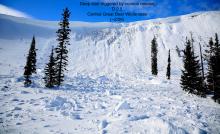
Natural avalanche activity tapered Tuesday as the storm quieted. We observed numerous natural avalanches that occurred during the storm in the Middle Fork corridor of the Flathead Range yesterday (Mt. Cameahwait, Loneman Mt.). BNSF Avalanche Safety also reported numerous natural avalanches in John F. Stevens Canyon in southern Glacier Park during the storm (Photo 1, Photo 2). Skiers on Elk Mt. in southern Glacier Park on Tuesday reported a natural avalanche in the northeast bowl as well as a rain crust that provided "terrible skiing" conditions.
Through our travels in the Marion Lake area near Essex yesterday we corroborated these conditions. A rain crust exists up to 6500 feet, at least in the Flathead Range and southern Glacier Park. Below 6500 feet this crust prevented any wind loading, but above this we found wind slabs about 6-10 inches thick (snow profile). This layer propagated fractures with easy force in our stability tests (video).
We received no observations from the Whitefish or Swan Ranges so we are uncertain about the existence of the rain crust as well as any lingering storm instabilities in those areas.
The past 48 hours post-storm saw a mixed bag of mountain weather. Cold arctic air moved back and forth in locations near the Continental Divide yesterday with mountain temperatures yo-yoing from near freezing to near 0º F. Other locations remained in the low to mid-30s F. As of 4:00 a.m., mountain temperatures range from 24º - 30º F. Winds recently switched from the southwest to the north-northeast at 5-15 with gusts to 25 mph. Today, expect dropping temperatures as another arctic air mass moves in from the east. Temperatures will range from mid-teens to the mid-20s F and winds will move out of the north-northeast at 10-20 with gusts to 30 mph. Light snow may fall in the mountains closer to the Continental Divide tonight with minor (up to 3 inches) accumulations.
| 0600 temperature: | 24-30 deg. F. |
| Max. temperature in the last 24 hours: | 31-37 deg. F. |
| Average wind direction during the last 24 hours: | Southwest switching to northeast |
| Average wind speed during the last 24 hours: | 5-15 mph |
| Maximum wind gust in the last 24 hours: | 25-27 mph |
| New snowfall in the last 24 hours: | 0 inches |
| Total snow depth: | 60-93 inches |
This advisory applies only to backcountry areas outside established ski area boundaries. This advisory describes general avalanche conditions and local variations always occur. This advisory expires at midnight on the posted day unless otherwise noted. The information in this advisory is provided by the USDA Forest Service who is solely responsible for its content.


