| Tuesday | Tuesday Night | Wednesday | |
|---|---|---|---|
| Cloud Cover: | Snow/Rain tapering this afternoon. Cold air moves in from east. | Drying and beginning to clear. | Clearing and dry. |
| Temperatures: | 26-38 deg. F. | 8-19 deg. F. | 26-38 deg. F. |
| Wind Direction: | West switching to Northeast. | East-Northeast | South-Southwest |
| Wind Speed: | 5-10 mph gusting to 25 mph. | 10-15 mph gusting to 35 mph. | 3-6 mph gusts to 10 mph. |
| Snowfall: | 5-7 in. | 0-1 in. | 0 in. |
| Snow Line: |
Whitefish Range
Swan Range
Flathead Range and Glacier National Park
How to read the forecast
The AVALANCHE WARNING continues through today throughout the advisory area including the Swan Range, Whitefish Range, Flathead Range, and portions of southern Glacier National Park. Snow accumulation yesterday reached over 30 inches in some locations. New snow, rain at lower to mid-elevations, wind, and rising temperatures continue to cause HIGH avalanche hazard. Natural and human triggered avalanches are likely. Travel in avalanche terrain and runout zones is not recommended.

4. High
?
Above 6500 ft.
4. High
?
5000-6500 ft.
4. High
?
3500-5000 ft.
- 1. Low
- 2. Moderate
- 3. Considerable
- 4. High
- 5. Extreme
-
Type ?
-
Aspect/Elevation ?

-
Likelihood ?CertainVery LikelyLikelyPossible
 Unlikely
 -
Size ?HistoricVery LargeLargeSmall

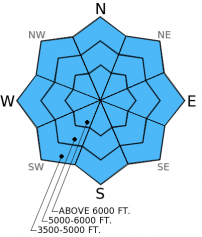
This new load on the snowpack is a big one, particularly in the Swan Range. Storm slabs could fail on the interface from Sunday's snow or at any given density change within the new storm snow. Given the sheer amount of new snow, storm slabs could be up to 3 feet deep or more. As new snow and rain with rising temperatures falls this morning even more stress will be added to the snowpack. Avoid avalanche terrain and runout zones today.
-
Type ?
-
Aspect/Elevation ?

-
Likelihood ?CertainVery LikelyLikelyPossible
 Unlikely
 -
Size ?HistoricVery LargeLargeSmall

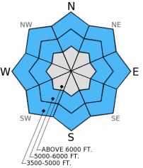
I really didn't want to list loose, wet avalanches as a problem in January, but today's conditions warrant it. Wet avalanches are likely, particularly at lower elevations given above freezing temperatures in many mountain locations along with continued rain. Rain rapidly adds weight to the snowpack and wet avalanches are likely to occur. These avalanches may be small, but can quickly knock you off your feet or bury you particularly in a terrain trap. If traveling at lower elevations pay attention to rapidly changing conditions as rain falls on new snow.
-
Type ?
-
Aspect/Elevation ?

-
Likelihood ?CertainVery LikelyLikelyPossible
 Unlikely
 -
Size ?HistoricVery LargeLargeSmall

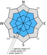
The weak layer of surface hoar and facets sitting on top of a melt-freeze crust from mid-December has shown signs of improvement over the last week. Most (but not all) recent stability tests show this layer unable to propagate fractures. However, this dragon may be awakened again with this new load. Though this weak layer is buried 2-4 feet deep and has become harder to trigger, new storm snow avalanches could step down into this weak layer. Avalanches that fail on this deep layer could be large and destructive. Today, continuing to avoid avalanche terrain and runout zones and allowing the snowpack time to adjust to this new load is the best way to manage this problem.
The AVALANCHE WARNING continues today. Rising temperatures and continued precipitation will continue through this morning. By this afternoon as a cold air mass moves back west again over most of the advisory area and precipitation ends, then avalanche activity should begin to taper. Until then, travel in avalanche terrain or runout zones is not recommended.
The Avalanche Warning will either be updated or allowed to expire by tomorrow morning at 7:00 a.m. The Flathead Avalanche Center issues regularly scheduled advisories Tuesday, Thursday, Saturday, and Sunday.
Even thought visbility is poor avalanches are occurring. BNSF Avalanche Safety reported several small magnitude (D1-2) avalanches at low to mid-elevations yesterday in the Middle Fork Corridor of the Flathead Range (image). These are great indicators of avalanche activity at upper elevations as well.
Yesterday, we traveled along the safety of a flat ridge in the southern Whitefish Range outside the Whitefish Mountain Resort boundary. We observed lots of cracking on low angled slopes. Visibility was poor so we didn't observe any natural avalanche activity. However, our stability test results showed the interface between Sunday's lower density snow and yesterday's heavier snow has the ability to propagate a fracture with easy force (video). This layer was about 50 cm (20 inches) from the surface. This is another great indicator of storm slab instability.
Updated images as of 1/6/2015 2:00 pm.

Low elevation natural avalanche activity in John F. Stevens Canyon, southern Glacier Park. Photo: BNSF Avalanche Safety
Yesterday was impressive. Here are storm totals from Sunday morning (1/4/15) through 4:00 am this morning. Note that most SNOTEL sites report every 3 hours so settlement can occur during that time. It's likely that snow amounts are under reported for this storm.
Noisy Basin: 30 inches snow (since Sat. night)/5.3 inches SWE
Pike Creek: 20 inches snow/1.8 inches SWE
Flattop Mt.: 15 inches snow/2.3 inches SWE
Stahl Peak: 7 inches snow/1.6 inches SWE
Shed 7: 15 inches snow
Big Mt.: 21 inches snow
Currently, mountain temperatures range from 29º to 36º F with winds moving out of the west at 5-15 mph gusting to 25 mph. Today, the weather is a bit more complicated. Freezing rain and rain to potentially 5500-6000 feet will continue until late morning/early afternoon. Then, another shot of arctic air moves west across the Divide from the east. Precipitation will taper by the afternoon. Expect rain/freezing rain and snow with potential accumulations of 5-7 inches through today.
| 0600 temperature: | 29-35 deg. F. |
| Max. temperature in the last 24 hours: | 29-35 deg. F. |
| Average wind direction during the last 24 hours: | Southwest |
| Average wind speed during the last 24 hours: | 5-15 mph |
| Maximum wind gust in the last 24 hours: | 27 mph |
| New snowfall in the last 24 hours: | 6-15 inches |
| Total snow depth: | 65-100 inches |
This advisory applies only to backcountry areas outside established ski area boundaries. This advisory describes general avalanche conditions and local variations always occur. This advisory expires at midnight on the posted day unless otherwise noted. The information in this advisory is provided by the USDA Forest Service who is solely responsible for its content.


