| Sunday | Sunday Night | Monday | |
|---|---|---|---|
| Cloud Cover: | Light snow | Increasing snow intensity and warming trend | Continuing snow with rising snow levels |
| Temperatures: | 8-21 deg. F. | 7-19 deg. F. | 23-34 deg. F. |
| Wind Direction: | East/Northeast | Southeast/Southwest | West/Southwest |
| Wind Speed: | 6-7 | 6-10 gusts 29 | 10-16 gusts 40 |
| Snowfall: | 1-4 in. | 12-18 in. | 5-20 in. |
| Snow Line: |
Whitefish Range
Swan Range
Flathead Range and Glacier National Park
How to read the forecast
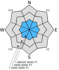
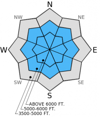
Winds increased yesterday afternoon and drifted new, low density snow and added depth to recently formed wind slabs. For today, the hazard is CONSIDERABLE on steep, wind loaded slopes above 6000 feet. On non-wind loaded slopes above 5000 feet the hazard is MODERATE, it remains possible to trigger an avalanche in weak snow buried 2-4 deep. Avoid steep, wind loaded terrain today and remain vigilant in assessing the snow pack for deeper instabilities.

3. Considerable
?
Above 6500 ft.
2. Moderate
?
5000-6500 ft.
1. Low
?
3500-5000 ft.
- 1. Low
- 2. Moderate
- 3. Considerable
- 4. High
- 5. Extreme
-
Type ?
-
Aspect/Elevation ?

-
Likelihood ?CertainVery LikelyLikelyPossible
 Unlikely
 -
Size ?HistoricVery LargeLargeSmall

Though wind speeds have not been impressive over the past few days, the recent snow is particularly light, and very low density allowing drifting to occur. As noted in recent observations, we found sensitive wind slabs in some locations in the last 48 hours and wind drifting continues to add depth to these slabs. In some areas wind slabs formed on top of persistent slabs which created a longer duration instability in these places. When traveling at high elevation be aware of the potential to find wind loaded slopes on different aspects due to recent wind shifts. Continue to avoid steep, wind loaded terrain today. Stick to more sheltered areas, and be cautious around features where cross-loading may have deposited mid-slope wind slabs like spur ridges, rock bands, and gulley walls.
-
Type ?
-
Aspect/Elevation ?

-
Likelihood ?CertainVery LikelyLikelyPossible
 Unlikely
 -
Size ?HistoricVery LargeLargeSmall

The persistent slab associated with weak snow buried 2-4 feet deep has been showing signs of improvement for several days now. However, it is still present in most areas in the region. The fact that these layers are becoming less reactive is only part of the reason human triggered avalanches have subsided, the other factor is that people have been wisely choosing conservative terrain due to the problem's widespread distribution. Continue to assess each new slope you intend to ski or ride for weak snow. Avoid areas where you are more likely to trigger a persistent slab like steep, rocky terrain, convex roll-overs, and areas where you find weak snow closer to the surface.
The next scheduled advisory will be Tuesday, January 6, 2015.
FAC snowmobile observers were in the Skyland area in the Flathead Range yesterday. They found the layer of buried surface hoar almost 2 feet deep in this area and were unable to propagate a fracture in stability tests. Late in the afternoon they observed an increase in wind and drifting snow along the ridge lines. On Friday, Erich was in the Lost Johnny drainage in the Swan Range and found sensitive wind slabs in some locations (video).
BNSF Avalanche Safety was in the John F Stevens Canyon on Friday and found a shallow snow pack with a layer of weak (faceted) snow above a melt-freeze crust that propagated a fracture in multiple stability tests.
Recent observations from skiers in several locations in the Flathead Range report the layer of buried surface hoar to be stubborn in stability tests. However, all parties noted that it's presence inspired conservative terrrain choices. Multiple skiers in the Flathead Range also observed weak snow near the surface and recent surface hoar development in isolated areas.
In the past 24 hours we picked up an additional 2-6 inches of new, low density snow. Temperatures were cold, and colder the closer you got to the divide, winds were light (5-10 mph) out of the north and east and increased to 10-20 mph late in the day. For today, expect a similar pattern as yesterday with light snowfall and temperatures reaching the high-teens to low-20s. Winds will remain out of the north and east at 5-15 mph with stronger gusts on the high ridges. This evening a more potent system moves into the area bringing warmer temperatures and 12-18 inches of snow.
| 0600 temperature: | -14-18 deg. F. |
| Max. temperature in the last 24 hours: | -4-18 deg. F. |
| Average wind direction during the last 24 hours: | North |
| Average wind speed during the last 24 hours: | 7-10 mph |
| Maximum wind gust in the last 24 hours: | 17-19 mph |
| New snowfall in the last 24 hours: | 2-6 inches |
| Total snow depth: | 57-80 inches |
This advisory applies only to backcountry areas outside established ski area boundaries. This advisory describes general avalanche conditions and local variations always occur. This advisory expires at midnight on the posted day unless otherwise noted. The information in this advisory is provided by the USDA Forest Service who is solely responsible for its content.


