| Thursday | Thursday Night | Friday | |
|---|---|---|---|
| Cloud Cover: | Cold, dry, and stagnant conditions will dominate the region today. Higher elevation temperatures will continue to moderate, while lower elevations will be slow to moderate under strong inversions. | Mostly Cloudy. | Cloudy with snow returning to the region. |
| Temperatures: | 16-26 deg. F. | 6-15 deg. F. | 18-28 deg. F. |
| Wind Direction: | Southwest | Southwest | Southwest |
| Wind Speed: | 3-5 mph with gusts to 15 mph. | 4-7 mph with gusts to 20 mph. | 8-15 mph with gusts to 30 mph. |
| Snowfall: | 0 in. | 0 in. | 1-3 in. |
| Snow Line: |
Whitefish Range
Swan Range
Flathead Range and Glacier National Park
How to read the forecast
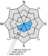
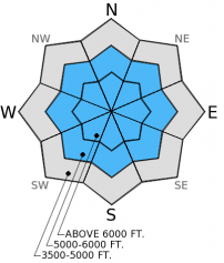
Happy New Year! Wind slabs at upper elevations and a weak layer (surface hoar and facets) buried 2-4 feet deep throughout the advisory area require careful snowpack evaluation, cautious route-finding, and conservative decision making. The hazard is CONSIDERABLE above 6000 feet today particularly on wind loaded slopes. On all other slopes it is possible to trigger an avalanche making the hazard MODERATE. See the advisory discussion for more information on today's hazard rating.

3. Considerable
?
Above 6500 ft.
2. Moderate
?
5000-6500 ft.
1. Low
?
3500-5000 ft.
- 1. Low
- 2. Moderate
- 3. Considerable
- 4. High
- 5. Extreme
-
Type ?
-
Aspect/Elevation ?

-
Likelihood ?CertainVery LikelyLikelyPossible
 Unlikely
 -
Size ?HistoricVery LargeLargeSmall

The strong winds earlier in the week created both hard and soft wind slabs on numerous aspects. Natural wind slab activity is an obvious sign of instability. Even though these slides are 2-3 days old, lingering wind slabs at upper elevations exist and triggering one is likely. These wind slabs also have the ability to step down into deeper persistent weak layers in the snowpack. Some of these wind slabs are hard and can sound hollow and drummy while others are softer and feel more "slabby". Wind slabs can be avoided by sticking to sheltered slopes and staying away from convex pillows of wind drifted snow.
-
Type ?
-
Aspect/Elevation ?

-
Likelihood ?CertainVery LikelyLikelyPossible
 Unlikely
 -
Size ?HistoricVery LargeLargeSmall

We clearly have evidence of instability associated with surface hoar and facets buried 2-4 feet deep from the surface in our snowpack. This problem certainly lives up to its moniker as a persistent slab. It may require more force now than a week ago to get this layer to propagate fractures in stability tests, but the take home point is that it STILL has the ability to propagate fractures. Obvious signs of instability (like recent avalanche activity) may be tapering, but on a steep slope (>35 degrees) this layer can still cause avalanches. With tricky conditions like this it becomes even more important to dig into the snow, identify the weak layer, and perform a stability test like an Extended Column Test (ECT). If the fracture propagates across the column that means this layer still has the ability to cause avalanches. In most stability tests this layer propagates fractures, but not in all. It is best to maintain a wide margin of safety to accomodate the uncertainty of this persistent slab problem. Like numerous recent observations illustrate this is best done by sticking to simple, low angled terrain and avoiding steep slopes and convex rollovers.
I am establishing the avalanche hazard today more on travel advice associated with the hazard rating than likelihood (though it is likely you'll trigger an avalanche on wind loaded terrain today). CONSIDERABLE danger suggests cautious route-finding, conservative decision making, and careful snowpack evaluation, and these are essential given our lurking persistent slab problem. We seem to be entering a low likelihood/high consequence situation where the probabilty of triggering a slide goes down, but the consequences are still high.
Numerous observers report sticking to simple, low angled terrain and choosing conservative lines to manage this instability. This is exactly what the travel advice for CONSIDERABLE danger implies. Thus, no human triggered avalanches were reported since Sunday (12/28/14). So, it appears as if most folks are indeed choosing less steep terrain. Not much has changed with the reactivity of this layer. It may require more force in stability tests, but it still has the ability to propagate fractures. One observer noted that under these conditions it is a gamble. You might be able to ride or ski a slope and get away with it, OR you might trigger an avalanche. It might not be the first person, but could be the second, third, or fourth (or more) person on the slope. Is it worth it? It's easy to incrementally move into steeper and more exposed terrain when you don't get immediate feedback of instability, but that doesn't necessarily mean it is stable. Just remember that tests are still showing instability, that weak layer still exists, and all it takes is one avalanche for things to go bad quickly. Let's all ring in 2015 with the goal of safely enjoying the mountains throughout the rest of the winter! Happy New Year from the Flathead Avalanche Center!
The next regularly scheduled advisory will be issued Saturday, January 3, 2015.
The strong north-northeast winds caused wind slabs to form at mostly upper elevations. In the Middle Fork corridor (Flathead Range) yesterday we and another party of skiers observed several natural wind slabs up to size D2.5 that occurred over the past 48-72 hours (image). BNSF Avalanche Safety also reported small natural wind slabs in southern Glacier Park on Tuesday.
The persistent weak layer of surface hoar and facets buried 2-4 feet deep above a melt-freeze crust continues to show instability in most stability tests. We found the surface hoar layer about 2 feet deep yesterday in the Marion Lake and Dickey Creek area, and it propagated fractures in all of our stability tests (video and snow profile). BNSF Avalanche Safety also found instability with this layer of facets above the crust (video). On Monday, this layer propagated fractures in the southern Whitefish Range (snow profile) and was the culprit failure layer of a skier triggered slide nearby on Sunday (video).
Other skiers yesterday near Half Moon in the southern Whitefish Range observed no propagation on this layer, but found instability in deeper layers. They opted for lower angled, simple terrain. Glacier National Park rangers also found the layer of surface hoar to propagate fractures in their stability tests yesterday on Peak 6996 (False Shields) in southern Glacier Park. This was the site of a skier triggered slide on Christmas Day last week.
The cold air mass remains entrenched over our area, but with moderating temperatures today. As of 4:00 am, mountain temperatures range from -4º to 8º F with light winds moving out of the southwest at 2-9 mph. Today, expect mountain temperatures to warm more than the previous few days to the upper teens and mid 20s F. Valley temperatures will remain colder due to strong temperature inversions. The next dose of precipitation appears to move in tomorrow.
| 0600 temperature: | -4 to 8 deg. F. |
| Max. temperature in the last 24 hours: | 10 deg. F. |
| Average wind direction during the last 24 hours: | Southwest |
| Average wind speed during the last 24 hours: | 2 to 9 mph |
| Maximum wind gust in the last 24 hours: | 14 to 19 mph |
| New snowfall in the last 24 hours: | 0 inches |
| Total snow depth: | 60-75 inches |
This advisory applies only to backcountry areas outside established ski area boundaries. This advisory describes general avalanche conditions and local variations always occur. This advisory expires at midnight on the posted day unless otherwise noted. The information in this advisory is provided by the USDA Forest Service who is solely responsible for its content.


