| Tuesday | Tuesday Night | Wednesday | |
|---|---|---|---|
| Cloud Cover: | Cold and mostly clear. Some clouds possible this afternoon. | Cold and mostly clear. | Beginning to warm. Partly Cloudy. |
| Temperatures: | 3 to 11 deg. F. | -12 to -3 deg. F. | 13 to 20 deg. F. |
| Wind Direction: | East | Switching to South | South-Southwest |
| Wind Speed: | 5-10 mph with gusts to 20 mph. | 5-10 mph with gusts to 20 mph. | 5 mph with gusts to 15 mph. |
| Snowfall: | 0 in. | 0 in. | 0 in. |
| Snow Line: |
Whitefish Range
Swan Range
Flathead Range and Glacier National Park
How to read the forecast
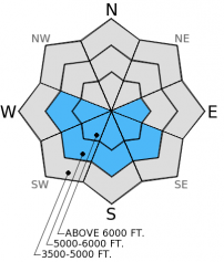
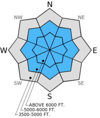
Tricky snowpack conditions require conservative decision making and careful terrain selection. Numerous human triggered avalanches were reported over the past eight days failing on a weak layer (buried surface hoar) 2-3 feet from the surface. Moderate to strong north-northeast winds over the past 48 hours created wind slabs above 5000 feet. Avoid wind loaded slopes and continue to stick to simple, low angled terrain. The avalanche hazard is CONSIDERABLE above 5000 feet and MODERATE below 5000 feet today.

3. Considerable
?
Above 6500 ft.
3. Considerable
?
5000-6500 ft.
2. Moderate
?
3500-5000 ft.
- 1. Low
- 2. Moderate
- 3. Considerable
- 4. High
- 5. Extreme
-
Type ?
-
Aspect/Elevation ?

-
Likelihood ?CertainVery LikelyLikelyPossible
 Unlikely
 -
Size ?HistoricVery LargeLargeSmall

Moderate to strong winds out of the northeast over the past 48 hours formed wind slabs on lee sides of ridges as well as cross loaded slopes and gullies. These north-northeast winds are loading slopes that may not be typically wind loaded. Wind slabs are both hard and soft, up to a foot thick, and can even be found in the middle of slopes due to strong winds. Look for and avoid convex pillows of wind drifted snow. Some of these wind loaded areas may have a chalky look to them and stability tests within the top few feet are a good way to assess the sensitivity of these wind slabs. Wind slab avalanches today may also step down to deeper persistent weak layers in the snowpack.
-
Type ?
-
Aspect/Elevation ?

-
Likelihood ?CertainVery LikelyLikelyPossible
 Unlikely
 -
Size ?HistoricVery LargeLargeSmall

A layer of buried surface hoar with a slab 2-4 feet thick sitting on top of it continues to be a persistent slab problem. This layer is responsible for numerous human triggered avalanches over the past eight days. With more snow sitting on top of this weak layer now it is becoming a bit more difficult to trigger in some places, but not in others. Stability tests and recent avalanche activity still show this layer has the ability to propagate fractures. While other obvious signs of instability like cracking and collapsing may not be present, this layer is still unstable and cannot be trusted. Most parties report choosing simple, low angled slopes (<35 degrees) (observations). Due to the tricky nature of this layer it is best to be conservative in your decision making process and choose terrain cautiously.
The snowpack is tricky right now and requires careful snowpack evaluation and cautious route-finding. Some slopes and stability tests may lead you to believe the snowpack is stable while other slopes are not. Recent human triggered avalanche activity over the past week illustrates the persistent slab problem well. It is not going away any time soon. This problem coupled with newly formed wind slabs forces us to be conservative and choose terrain carefully.
Last week certainly packed a punch with new snow and avalanches. Multiple storms deposited substantial loads on a snowpack containing a problematic weak layer of buried surface hoar and facets sitting on top of a melt-freeze crust. Numerous human triggered avalanches were reported in all of the mountain ranges throughout the advisory area over the past eight days. The ones we were able to examine failed on this surface hoar layer. Yesterday, we investigated a reported slide that occurred Sunday (12/28) in the Canyon Creek area in the southern Whitefish Range outside the Whitefish Mountain Resort boundary (video). This avalanche failed on the surface hoar layer with a crown depth ranging from 1 - 3.5 feet deep and approximately 100 feet wide on a 38 degree slope. Noone was caught. This avalanche was about 30 feet away (on the same slope) from an avalanche that we triggered safely from the ridge last Wednesday (12/24). The crown from that earlier avalanche was still visible but partially filled in. Our stability tests on other aspects showed this layer of surface hoar still has the ability to propagate fractures (snow profile).
Skiers in the northern Swan Range yesterday found about 4 feet of snow sitting on top of the surface hoar and melt-freeze crust layers. This layer did not propagate fractures in their stability tests. They noted variable skiing conditions due to wind affected snow within the top foot of the snowpack.


Crown of skier triggered slide in Canyon Creek (12/28). Crown of skier triggered slide in Canyon Creek (12/28).
Brrr! A cold air mass infiltrated the region over the past 48 hours and brought moderate (17-25 mph) to strong (26-38 mph) north-northeast winds. Currently, mountain temperatures range from -19º F to -1º F and winds remain out of the north-northeast at 5-10 mph with gusts to 20 mph. This pattern will continue through tomorrow with dry and cold conditions and subsiding winds expected.
| 0600 temperature: | -19 to -1 deg. F. |
| Max. temperature in the last 24 hours: | -6 to 2 deg. F. |
| Average wind direction during the last 24 hours: | North-Northeast |
| Average wind speed during the last 24 hours: | 5-20 mph |
| Maximum wind gust in the last 24 hours: | 20-40 mph |
| New snowfall in the last 24 hours: | 0 inches |
| Total snow depth: | 59-80 inches |
This advisory applies only to backcountry areas outside established ski area boundaries. This advisory describes general avalanche conditions and local variations always occur. This advisory expires at midnight on the posted day unless otherwise noted. The information in this advisory is provided by the USDA Forest Service who is solely responsible for its content.


