| Saturday | Saturday Night | Sunday | |
|---|---|---|---|
| Cloud Cover: | Light snow increasing late afternoon | Continued snow | Snow showers and cooler temperatures |
| Temperatures: | 21-27 deg. F. | 12-22 deg. F. | 16-24 deg. F. |
| Wind Direction: | SW | SW | N/NE |
| Wind Speed: | 10-16 gusts 28-32 | 5-15 gusts 20-25 | 13-18 gusts 33 |
| Snowfall: | 2-3 in. | 6-10 in. | 2-4 in. |
| Snow Line: |
Whitefish Range
Swan Range
Flathead Range and Glacier National Park
How to read the forecast
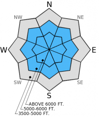
Recent human triggered and natural avalanches associated with a layer of buried surface hoar were reported in six of the last seven days. Though obvious signs of instability may subside, little has changed to improve this weak layer. For today the avalanche hazard is rated considerable above 5000 feet. Human triggered avalanches are likely, particularly on steep slopes. Continue to play it safe and avoid steep terrain and convex roll-overs.

3. Considerable
?
Above 6500 ft.
3. Considerable
?
5000-6500 ft.
2. Moderate
?
3500-5000 ft.
- 1. Low
- 2. Moderate
- 3. Considerable
- 4. High
- 5. Extreme
-
Type ?
-
Aspect/Elevation ?

-
Likelihood ?CertainVery LikelyLikelyPossible
 Unlikely
 -
Size ?HistoricVery LargeLargeSmall

We have observed a layer of buried surface in most locations within the advisory area at depths varying from 18 inches to almost 3 feet. This layer is proving to be reactive in most stability tests but provides seemingly stable results in some locations. Remember that stability tests are only one piece of the puzzle and recent avalanche activity always trumps stability test findings. The snowpack may not provide us with the bulls eye clues of instability such as shooting cracks, collapsing, or natural avalanche activity, however this persistent slab deserves respect until it proves less reactive. There is a lot of good, low angle skiing and riding out there, resist the temptation to move into steeper terrain based on positive feedback from less steep slopes.
With strong wind gusts expected on the ridgetops, pay attention to drifting snow and fresh wind slab formation on leeward slopes today. The wind has the ability to rapidly load a slope and stress weak layers in the snowpack.
Yesterday we were in the Flathead Range traveling in the Skyland area. In the morning while we still had good visibility we observed several crown lines from recent avalanches on surrounding peaks (photo). We dug snow pits on multiple aspects and elevations and the common denominator was a layer of buried surface hoar that varied from 1.5 to 3 feet deep in the snow pack. In each of our stability tests this layer proved capable of propagating a fracture with moderate force (video). Recent abundant snowfall made for excellent skiing and riding conditions on low angle terrain.
On Thursday, skiers in southern Glacier National Park triggered an avalanche that propagated a long distance across the slope (observation). A good illustration of the tricky nature of our snowpack came the following day when skiers in the same area found seemingly stable results (ECTX) in stability tests on the same aspect and elevation as the skier triggered avalanche one day prior (observation). These findings conflicted with the recent avalanche activity they observed. The party respected the tricky snowpack and obvious signs of instability and chose terrain conservatively.
On Wednesday, two parties skiing in the southern Whitefish Range reported unstable results in stability tests.
We did not receive any recent observations from the Swan Range.
Yesterday we saw a short break in the series of storm systems moving through the area. Snow showers today could deliver up to 6 inches of low density snow in some locations. Mountain temperatures today range from the mid-teens to mid-20s, winds will be out of the southwest 5-15 mph with gusts in the mid-30s on ridgetops. Snow intensity is expected to increase this afternoon and continue overnight. Tomorrow should see even cooler temperatures with a few lingering snow showers.
| 0600 temperature: | 10-18 deg. F. |
| Max. temperature in the last 24 hours: | 18-22 deg. F. |
| Average wind direction during the last 24 hours: | SW |
| Average wind speed during the last 24 hours: | 5-15 mph |
| Maximum wind gust in the last 24 hours: | 20 mph |
| New snowfall in the last 24 hours: | 0-3 inches |
| Total snow depth: | 53-93 inches |
This advisory applies only to backcountry areas outside established ski area boundaries. This advisory describes general avalanche conditions and local variations always occur. This advisory expires at midnight on the posted day unless otherwise noted. The information in this advisory is provided by the USDA Forest Service who is solely responsible for its content.


