| Wednesday | Wednesday Night | Thursday | |
|---|---|---|---|
| Cloud Cover: | Snow and dropping temperatures later today. | Cloudy with snow beginning later tonight. | Snow intensity increases in the early morning and continues through the day. |
| Temperatures: | 29-36 deg. F. | 11-22 deg. F. | 19-31 deg. F. |
| Wind Direction: | Southwest | North-Northwest | West-Southwest |
| Wind Speed: | 10-20 mph with gusts to 35 mph. | 10-15 mph with gusts to 25 mph. | 5-10 mph with gusts to 25 mph. |
| Snowfall: | 4-7 in. | 4-10 in. | 1-3 in. |
| Snow Line: |
Whitefish Range
Swan Range
Flathead Range and Glacier National Park
How to read the forecast
AVALANCHE WARNING issued for entire advisory area including the Whitefish, Swan, and Flathead Ranges, and portions of Glacier Park. The avalanche hazard is HIGH. Very dangerous avalanche conditions exist. Human triggered avalanches reported every day over the last four days. New snow and winds over buried surface hoar 1.5 to 2.5 feet deep make human triggered avalanches very likely and natural avalanches likely with the potential to be large and destructive. Travel in avalanche terrain is not recommended.

4. High
?
Above 6500 ft.
4. High
?
5000-6500 ft.
4. High
?
3500-5000 ft.
- 1. Low
- 2. Moderate
- 3. Considerable
- 4. High
- 5. Extreme
-
Type ?
-
Aspect/Elevation ?

-
Likelihood ?CertainVery LikelyLikelyPossible
 Unlikely
 -
Size ?HistoricVery LargeLargeSmall

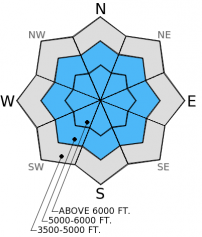
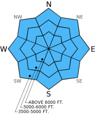
Imagine potato chips sitting underneath a brick. Maybe some can support the first brick, but any more bricks and ,WHAM!, the chips break. Such is the life of our current snowpack and today's new load will cause avalanches. The layer of buried surface hoar now about 20-30 inches from the surface continues to cause problems across the advisory area. This weak layer is sensitive and has the propensity to propagate far and wide. Avalanches today could be large given the new load. Reports of remote triggering over the weekend and continued human triggered slides Monday and Tuesday illustrate the ability of this layer to propagate fractures. These avalanches can be unpredictable and surprising and require a wide safety buffer to handle the uncertainty. This includes avoiding avalanche terrain today as well as runout zones.
-
Type ?
-
Aspect/Elevation ?

-
Likelihood ?CertainVery LikelyLikelyPossible
 Unlikely
 -
Size ?HistoricVery LargeLargeSmall

New snow and moderate to strong southwest winds overnight make storm slabs and wind slabs a problem today. With rising temperatures overnight the new snow will be slightly upside down (more dense over less dense snow). Expect both storm slabs and wind slabs to increase in thickness as the day progresses. These slabs will add more stress to an already weak layer, and, if triggered, have the ability to step down to the layer of buried surface hoar.
This storm looks to continue through today into tomorrow. Stability will get worse before it gets better.Note: Big Mt. Summit weather station wind sensor values are invalid. The wind sensor requires maintenance. We are headed up there on Friday to troubleshoot. Thanks for your patience.
The Avalanche Warning will either be allowed to expire or updated tomorrow morning by 7:00 am.
Reports of human triggered avalanches continued yesterday. Skiers in the southern Whitefish Range reported 2 separate (both intentional and unintentional) human triggered avalanches in the Canyon Creek area (image) failing on the surface hoar layer above the melt-freeze crust. The storm Saturday into Sunday buried surface hoar about 40-50 cm (16-20 inches) deep in most locations across the advisory area and current snowfall will bury it even deeper.
Numerous parties reported natural and human triggered avalanches Saturday into Sunday (observations) throughout the Swan and Whitefish ranges. On Monday we rode into the Red Meadow area in the northern Whitefish Range and unintentionally triggered a small convex rollover (image) and a cut bank along the road into Red Meadow (image). We investigated both slides (video and snow profile) and avoided steep slopes and runout zones all day.
BNSF Avalanche Safety reported collapsing of the snowpack in their travels yesterday in John F. Stevens Canyon in southern Glacier Park. They also reported natural activity from last weekend with a crown that reached back into lower angled terrain (<30 degrees).


Skier triggered slide in southern Whitefish Range (Beaver Ponds). Cut bank along the road to Red Meadow Lake.

John F. Stevens Canyon, southern Glacier Park. Photo: BNSF Avalanche Safety
Snowfall began last night and continues through the early morning across the advisory area. As of 4:00 am, mountain temperatures range from 23º-31º F with winds moving out of the southwest at 5-15 mph gusting to 35 mph. Snow totals thus far across the advisory area range from 3-9 inches with 0.4-0.9 inches of snow water equivalent (SWE). All of this fell within the past 9 hours. This is a rapid load! Expect snowfall to contiue today into tonight with an additional 5-8 inches by tonight. Winds will be out of the southwest most of the day 10-20 mph with gusts into the 35-45 mph range.
| 0600 temperature: | 23-31 deg. F. |
| Max. temperature in the last 24 hours: | 31 deg. F. |
| Average wind direction during the last 24 hours: | SW |
| Average wind speed during the last 24 hours: | 4-15 mph |
| Maximum wind gust in the last 24 hours: | 34 mph |
| New snowfall in the last 24 hours: | 4-10 inches |
| Total snow depth: | 44-62 inches |
This advisory applies only to backcountry areas outside established ski area boundaries. This advisory describes general avalanche conditions and local variations always occur. This advisory expires at midnight on the posted day unless otherwise noted. The information in this advisory is provided by the USDA Forest Service who is solely responsible for its content.


