| Tuesday | Tuesday Night | Wednesday | |
|---|---|---|---|
| Cloud Cover: | Mostly cloudy with a slight chance of snow. Increasing chances this afternoon. | Cloudy with snow beginning later tonight. | Snow intensity increases in the early morning and continues through the day. |
| Temperatures: | 26-32 deg. F. | 24-28 deg. F. | 29-35 deg. F. |
| Wind Direction: | Southwest | Southwest | Southwest |
| Wind Speed: | 5-10 mph with gusts to 20 mph. | 13-20 mph with gusts to 35 mph. | 14-18 mph with gusts to 35 mph. |
| Snowfall: | 0 in. | 2-5 in. | 4-8 in. |
| Snow Line: |
Whitefish Range
Swan Range
Flathead Range and Glacier National Park
How to read the forecast
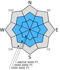
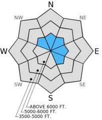
The avalanche hazard above 5000 feet is CONSIDERABLE today. Dangerous avalanche conditions exist. Buried surface hoar 1.5 to 2 feet deep and fresh wind slabs continue to make human triggered avalanches likely. These conditions require careful snowpack evaluation, cautious route-finding, and conservative decision making.

3. Considerable
?
Above 6500 ft.
3. Considerable
?
5000-6500 ft.
2. Moderate
?
3500-5000 ft.
- 1. Low
- 2. Moderate
- 3. Considerable
- 4. High
- 5. Extreme
-
Type ?
-
Aspect/Elevation ?

-
Likelihood ?CertainVery LikelyLikelyPossible
 Unlikely
 -
Size ?HistoricVery LargeLargeSmall

The layer of buried surface hoar about 16-20 inches from the surface continues to cause problems across the advisory area. Without new snow over the past 24-36 hours, this problem has become a persistent slab. While natural avalanche activity involving this layer tapered since Sunday, human triggered avalanches are still likely. The two small avalanches we investigated yesterday occurred on slopes 35 degrees and steeper. However, they both ran onto less steep slopes below. This weak layer is sensitive and has the propensity to propagate far and wide. Reports of remote triggering over the weekend illustrate the ability of this layer to propagate fractures. These avalanches can be unpredictable and surprising and require a wide safety buffer to handle the uncertainty. This includes avoiding steep slopes or lesser angled terrain connected to steep terrain like runout zones.
-
Type ?
-
Aspect/Elevation ?

-
Likelihood ?CertainVery LikelyLikelyPossible
 Unlikely
 -
Size ?HistoricVery LargeLargeSmall

Moderate (17-25 mph) southwest winds yesterday caused wind slabs to form at upper elevations and on cross-loaded slopes. These wind slabs will add more stress to an already weak layer, and, if triggered, have the ability to step down to the layer of buried surface hoar. Slabs on wind loaded slopes could be even deeper than the 20 inch slabs observed with persistent slabs. Look for and avoid wind slabs on convex rollovers and on lee sides of ridges.
Dangerous avalanche conditions exist. Given current conditions, it is essential to be conservative in your decision making and use cautious route-finding techniques that include avoiding steep slopes. As the storm rolls in tonight, the hazard could increase quickly again with a new load stressing the surface hoar layer even more.
The next scheduled advisory will be issued Thursday, December 25, 2014.
Well, instability is pretty obvious when it smacks us in the face with natural and human triggered avalanches. The storm Saturday into Sunday buried the surface hoar about 40-50 cm (16-20 inches) deep in most locations across the advisory area. Numerous parties reported natural and human triggered avalanches Saturday into Sunday (observations) throughout the Swan and Whitefish ranges. Yesterday, we rode into the Red Meadow area in the northern Whitefish Range. We saw no natural avalanches occur yesterday, but unintentionally triggered a small convex rollover (image) and a cut bank along the road into Red Meadow (image). We investigated both slides (video and snow profile) and avoided steep slopes and runout zones all day. We also received a report yesterday of cracking (another obvious sign of instability) on low angled terrain in the southern Whitefish Range.


Crown depth=40-50 cm. Width=100 ft. Failure layer=surface hoar. Slope angle=35 degrees. Cut bank along the road to Red Meadow Lake.
Note: SNOTEL sites have not reported since 10:00 pm last night. Values this morning are limited from other non-SNOTEL sites in the area.
Mostly dry conditions will prevail today ahead of a strong storm system moving into the area from the northwest tonight through tomorrow. As of 4:00 am, mountain temperatures range from 16º-20º F with winds moving out of the southwest at 6-8 mph gusting to 20 mph. Around 1 inch of new snow fell over the past 24 hours. Tonight, a storm system moves into the region bringing an increase in winds and new snow. Snow amounts over the next 48 hours could total up to a foot or more. Stay tuned!
| 0600 temperature: | 16-20 deg. F. |
| Max. temperature in the last 24 hours: | 24 deg. F. |
| Average wind direction during the last 24 hours: | SW |
| Average wind speed during the last 24 hours: | 5-10 mph |
| Maximum wind gust in the last 24 hours: | 17-34 mph |
| New snowfall in the last 24 hours: | 1 inches |
| Total snow depth: | 44-58 inches |
This advisory applies only to backcountry areas outside established ski area boundaries. This advisory describes general avalanche conditions and local variations always occur. This advisory expires at midnight on the posted day unless otherwise noted. The information in this advisory is provided by the USDA Forest Service who is solely responsible for its content.


