| Saturday | Saturday Night | Sunday | |
|---|---|---|---|
| Cloud Cover: | Mostly cloudy with light snow showers | Warming with increased precipitation. | Continued precipitation with snow levels rising to 5-6000 feet. |
| Temperatures: | 30-37 deg. F. | 29-32 deg. F. | 34-40 deg. F. |
| Wind Direction: | south/southwest | south/southwest | west/southwest |
| Wind Speed: | 7-11 | 10-15 | 12-18 |
| Snowfall: | 0-1 in. | 3-6 in. | 1-6 in. |
| Snow Line: |
Whitefish Range
Swan Range
Flathead Range and Glacier National Park
How to read the forecast
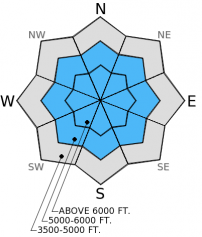
New snow and wind drifted snow accumulated on a weak snow surface yesterday and overnight. Continued winds and a small amount of new snow today will continue to add stress to this layer of buried surface hoar. Human triggered avalanches are likely particularly on wind loaded slopes. Conservative decision making while traveling in the back country will be essential today.

3. Considerable
?
Above 6500 ft.
3. Considerable
?
5000-6500 ft.
2. Moderate
?
3500-5000 ft.
- 1. Low
- 2. Moderate
- 3. Considerable
- 4. High
- 5. Extreme
-
Type ?
-
Aspect/Elevation ?

-
Likelihood ?CertainVery LikelyLikelyPossible
 Unlikely
 -
Size ?HistoricVery LargeLargeSmall

Recent new snow and wind drifted snow ontop of buried surface hoar and weak snow above a crust formed last week will be a concern today. The melt-freeze crust will provide a great bed surface for new slabs to slide on. New unconsolidated snow was easily sluffing on slopes steeper than 35 degrees yesterday, the combination of settlement and wind drifting likely formed soft slabs over the buried surface hoar today. For today it would be best to stick to low angle slopes and avoid wind loaded terrain.
-
Type ?
-
Aspect/Elevation ?

-
Likelihood ?CertainVery LikelyLikelyPossible
 Unlikely
 -
Size ?HistoricVery LargeLargeSmall

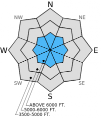
The weak snow near the ground throughout our advisory area continues to show signs of strengthening. However, in isolated areas, particularly areas with a shallow snowpack (typically three feet or less), this layer still shows signs of instability by propagating fractures in stability tests. Getting this layer to fracture and propagate in extended column tests is becoming increasingly more difficult, but the results cannot be ignored. Managing this problem is best done by avoiding steep slopes with a shallow snowpack. It's important to assess this layer on slopes you want to ski or ride. While obvious signs of instabilty (like cracking and collapsing) are lacking, this layer could become an issue again as new snow loads the snowpack in the coming days.
Given that temperatures are on the rise today the potential to trigger loose, wet avalanches at lower elevations will increase if temperatures rise above freezing. If snow surface becomes moist and you observe early signs of loose, wet avalanches such as roller balls avoid terrain that could be consequential even with small avalanches like narrow gullies and cliff areas.
Yesterday we were in Noisy Basin and Jewel Basin in the Swan Range. We saw 4 inches of new snow fall in the time we were out. Along the ridge top 5-15 mph winds drifted the new snow on to leeward slopes. We found surface hoar on most aspects that was buried up to 6 inches deep in the snow pack above 5000 feet. Except for wind affected areas just below the ridgeline the recent snow was unconsolidated and had yet to form a slab over the weak surface hoar layer (video,photo). In isolated areas where a soft slab had formed we observed obvious signs of instability in the form of shooting cracks from our skis. We dug to the ground on several aspects to assess the persistent slab problem and found signs of continued improvement evidenced by our inability to propagate a fracture in stability tests. We were in areas with a relatively deep snow pack which may have contributed to the unreactive weak (faceted) snow near the ground, but it is important to remember that this problem layer still exists. Assess the areas that you intend to ski or ride for weak snow near the ground and avoid areas where you are most likely to trigger an avalanche in this layer like in steep, rocky terrain with shallow snow (photo).
Erich was in the Whitefish Range yesterday and experienced shooting cracks on slopes where a slab had formed on top of weak snow above the crust, but not on slopes where the slab had yet to form.
Yesterday, WMR ski patrol conducted avalanche control in the ski area. They were able to produce loose snow avalanches in 6-8 inches of recent snow on top of a supportable melt-freeze crust. Late in the day they observed soft slabs forming in the new snow along the ridgelines (observation).
Currently, mountain temperatures range from 22-28º F and winds are 7-14 mph out of the southwest. In the past 24 hours, between 4 and 7 inches of new snow fell across the area with winds out of the southwest at 5-15 mph gusting up to 25 mph. Today, mountain temperatures are expected to remain in the upper 20s to low 30s and winds will be out the southwest at 5-15 mph with gusts in the 40s. We will see mostly cloudy skies and light snow showers today with 1-2 inches of new snow possible. Temperatures and snow levels will begin to rise today through tonight along with increased precipitation intensity this evening.
| 0600 temperature: | 22-28 deg. F. |
| Max. temperature in the last 24 hours: | 27-32 deg. F. |
| Average wind direction during the last 24 hours: | SW |
| Average wind speed during the last 24 hours: | 5-15 mph |
| Maximum wind gust in the last 24 hours: | 26 mph |
| New snowfall in the last 24 hours: | 4-7 inches |
| Total snow depth: | 45-51 inches |
This advisory applies only to backcountry areas outside established ski area boundaries. This advisory describes general avalanche conditions and local variations always occur. This advisory expires at midnight on the posted day unless otherwise noted. The information in this advisory is provided by the USDA Forest Service who is solely responsible for its content.


