| Tuesday | Tuesday Night | Wednesday | |
|---|---|---|---|
| Cloud Cover: | Clear becoming cloudy this afternoon. | Mostly cloudy. | Mix of sun and clouds. |
| Temperatures: | 26-33 deg. F. | 18-25 deg. F. | 28-33 deg. F. |
| Wind Direction: | South-Southwest | Southwest | Southwest |
| Wind Speed: | 1-5 with gusts to 10 mph. | 5 mph. | 4-10 mph. |
| Snowfall: | 0 in. | 0 - 1 in. | 0 in. |
| Snow Line: |
Whitefish Range
Swan Range
Flathead Range and Glacier National Park
How to read the forecast
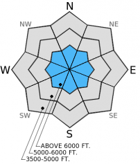
The snowpack continues to show signs of strengthening. However, some signs of instability still exist on slopes with a shallow snowpack. Above 6000 feet the avalanche hazard is MODERATE on slopes steeper than 35 degrees. The hazard is LOW in all other locations. It is still important to evaluate all slopes before riding or skiing, particularly areas with a shallow snowpack.

2. Moderate
?
Above 6500 ft.
1. Low
?
5000-6500 ft.
1. Low
?
3500-5000 ft.
- 1. Low
- 2. Moderate
- 3. Considerable
- 4. High
- 5. Extreme
-
Type ?
-
Aspect/Elevation ?

-
Likelihood ?CertainVery LikelyLikelyPossible
 Unlikely
 -
Size ?HistoricVery LargeLargeSmall

Yes, we are still talking about the weak snow (facets) near the ground. That is the reason it is called a persistent slab. This layer near the ground still exists throughout the advisory area. In most locations it continues to gain strength, but in other areas it is still producing unstable results in our stability tests. It is becoming increasingly more difficult for this layer to propagate a fracture in tests, but in areas with a shallow snowpack (typically three feet or less) it is still reliably reactive. So, managing this problem is best done by avoiding steep slopes with a shallow snowpack. Given that riding and skiing conditions are less than ideal right now, take a few minutes when you are out to dig down to this layer and examine how reactive it may or may not be.
New snow amounts from last Saturday weren't particularly impressive with the exception of the Swan Range. As mentioned this new snow sits on top of a strong melt-freeze crust that provides a perfect bed surface. Loose snow sluffs are possible today but should not be a big problem. Wet loose sluffs are also possible if the temperature rises above freezing and with abundant sunshine. These should be small, but could be problematic in high consequence terrain (like cliff areas).
Finally, your observations are very valuable to us! If you are out in the backcountry please send us your observations. It's really easy (video). Give us a call (406.387.3835), email us at [email protected], or send them to us via our Observations page.
The next scheduled advisory will be issued Thursday, December 18, 2014.
The new snow from Saturday in the Flathead Range (Middle Fork corridor) did very little to improve riding and skiing conditions (perhaps we all need to start doing a bit more snow dancing?). Last week's unseasonably warm temperatures and a subsequent refreeze created a thick melt-freeze crust underneath this new snow (dust on crust). Yesterday, we found these conditions on all aspects up to 7000 feet. The new snow was very light and ran easily on this crust underneath as loose snow sluffs or point releases (image). The past cold clear nights allowed surface hoar to form at the surface (image) in the Flathead Range (Paola and Tunnel Creek area) yesterday as well as in the southern Whitefish Range (observation), and this is important to observe for future storms as this could become a future weak layer. We also ran into those pesky facets near the ground which are displaying variable results in stability tests and are still a concern (video).
Others observed loose, wet sluffs and small point release slides on sunny aspects on Sunday in Canyon Creek in the southern Whitefish Range as well as on Mt. Edwards in Glacier National Park.
Interestingly, we also observed a couple of glide avalanches likely from last week and even after this most recent snow (image). While not a major problem, particularly after this refreeze, these avalanches failed on smooth, rock slabs at upper elevations indicating that free water is moving along the base of the snowpack at the ground.
High pressure has set in over our region bringing mostly sunny skies and temperatures at a more reasonable winter-like level as opposed to last week. As of 4:00 am, mountain temperatures across the advisory area range from 12-21º F with winds a bit variable out of the south in some locations and north in others at 5-10 mph. Today, expect temperatures to reach into the low 30s F with light winds at 5-10 mph generally out of the south.
| 0600 temperature: | 15-21 deg. F. |
| Max. temperature in the last 24 hours: | 27 deg. F. |
| Average wind direction during the last 24 hours: | NE switching to S |
| Average wind speed during the last 24 hours: | 1-10 mph |
| Maximum wind gust in the last 24 hours: | 11-16 mph |
| New snowfall in the last 24 hours: | 0 inches |
| Total snow depth: | 34-45 inches |
This advisory applies only to backcountry areas outside established ski area boundaries. This advisory describes general avalanche conditions and local variations always occur. This advisory expires at midnight on the posted day unless otherwise noted. The information in this advisory is provided by the USDA Forest Service who is solely responsible for its content.


