| Saturday | Saturday Night | Sunday | |
|---|---|---|---|
| Cloud Cover: | Mostly cloudy with snow showers, cooling today. | Decreasing snow showers. | Partly/mostly cloudy with cooler temperatures. |
| Temperatures: | 30-35 deg. F. | 22-27 deg. F. | 27-34 deg. F. |
| Wind Direction: | west | west | west/southwest |
| Wind Speed: | 7-11 | 4-7 | 2-4 |
| Snowfall: | 2-4 in. | 1-2 in. | 0.0 in. |
| Snow Line: |
Whitefish Range
Swan Range
Flathead Range and Glacier National Park
How to read the forecast
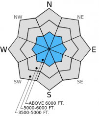
Recent warming has contributed to the strengthening of some mid-snowpack instability, however it remains possible to trigger avalanches in weak snow (facets) near the ground in some locations. Continue to seek out these instabilities in the areas you are skiing or riding. Pay close attention to changing conditions in regard to new snow and associated winds in the forescast.

2. Moderate
?
Above 6500 ft.
1. Low
?
5000-6500 ft.
1. Low
?
3500-5000 ft.
- 1. Low
- 2. Moderate
- 3. Considerable
- 4. High
- 5. Extreme
-
Type ?
-
Aspect/Elevation ?

-
Likelihood ?CertainVery LikelyLikelyPossible
 Unlikely
 -
Size ?HistoricVery LargeLargeSmall

With recent warm temperatures and several days without added stress to the snowpack many of the persistent slabs in the area have gained strength, particularly those in the mid-snowpack. That said, persistent slabs in the form of weak (faceted) snow near the ground still exist in most areas. With time to settle, it has and will likely continue to be more difficult to trigger an avalanche in this layer but the possiblity remains. Continue to avoid areas where you are most likely to trigger an avalanche in this layer such as steep, rocky terrain and areas that are notorious for harboring shallow snow. Assess each slope you intend to ski or ride for persistent slab, and if possible, let us know what you find.
Though unseasonably warm yesterday, it was a beautiful day to travel in the Skyland vicinity of the Flathead Range. Visibility was seemingly unlimited. At lower elevations we observed debris from small, loose, wet avalanches on steep slopes that occured during warm and sunny days earlier in the week. At 5000-6500 feet we noted recent roller balls (photo), but did not observe any recent avalanche activity on mid to high elevation slopes. We climbed a ridge above 25-Mile Creek on a breakable melt-freeze crust that began to soften on sunny aspects in the early afternoon. In a snow pit on an east aspect at 7050 feet we found weak, sugary snow (facets) near the ground where we were able to propagate a fracture with hard force in stability tests. We also found similar conditions earlier in the week in on a slope in Noisy Basin that had a shallow snowpack. In other snow pits we did not find the weak snow near the ground to be as reactive and showed signs of rounding and strengthening (video). Though there were no alarming results in stability testing, it is worth noting a layer of buried surface hoar we found about 1 foot down in the snowpack, particularly as we add weight to that layer in future storms (photo).
Yesterday, Erich and Lucas were in Red Meadow in the Whitefish Range. They noted saturated surface snow up to about 7000 feet and a little less than 1 inch of new snow above that from a brief precipitation event Thursday night. Extended column testing in multiple locations did not produce any propagations. They observed small loose, wet avalanches and roller balls from previous days' sun and above freezing temps
I am happy to see temperatures trending back toward the right side of freezing for this time of year. Yesterday Pike Creek SNOTEL recorded a high temperature of 51F. Currently mountain temperatures range from 29-39F and should continue to fall this morning. For today, expect continued snow showers tapering in the afternoon. Winds will be 5-15 mph out of the west and northwest with stronger gusts on the ridge tops. Tomorrow should remain cool and dry as weak ridge of high pressure builds over the area.
| 0600 temperature: | 29-39 deg. F. |
| Max. temperature in the last 24 hours: | 36-51 deg. F. |
| Average wind direction during the last 24 hours: | SW |
| Average wind speed during the last 24 hours: | 5-15 mph |
| Maximum wind gust in the last 24 hours: | 19 mph |
| New snowfall in the last 24 hours: | 0.00 inches |
| Total snow depth: | 5-41 inches |
This advisory applies only to backcountry areas outside established ski area boundaries. This advisory describes general avalanche conditions and local variations always occur. This advisory expires at midnight on the posted day unless otherwise noted. The information in this advisory is provided by the USDA Forest Service who is solely responsible for its content.


