| Thursday | Thursday Night | Friday | |
|---|---|---|---|
| Cloud Cover: | Cloudy with rain showers. | Cloudy with rain showers. | Cloudy with dropping snow levels. |
| Temperatures: | 38-45 deg. F. | 31-36 deg. F. | 36-44 deg. F. |
| Wind Direction: | South-Southwest | South-Southwest | South-Southwest |
| Wind Speed: | 12-18 with gusts to 25 mph. | 10-15 with gusts to 30 mph. | 5-15 with gusts to 45 mph. |
| Snowfall: | 0 in. | 0 in. | 0 in. |
| Snow Line: |
Whitefish Range
Swan Range
Flathead Range and Glacier National Park
How to read the forecast
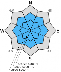
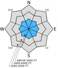
Human triggered avalanches are possible due to lingering instability of weak snow (facets) near the ground. Wet avalanches are also possible due to rain and above freezing temperatures. Carefully evaluate each slope before you commit to it and avoid steep, rocky slopes with shallow snow where it is easier to trigger this weak snow near the ground. Pay attention to changing conditions throughout the day particularly during rain events. If it rains more than expected, the hazard will rise.

2. Moderate
?
Above 6500 ft.
2. Moderate
?
5000-6500 ft.
1. Low
?
3500-5000 ft.
- 1. Low
- 2. Moderate
- 3. Considerable
- 4. High
- 5. Extreme
-
Type ?
-
Aspect/Elevation ?

-
Likelihood ?CertainVery LikelyLikelyPossible
 Unlikely
 -
Size ?HistoricVery LargeLargeSmall

Yesterday, loose, wet avalanches were a problem due to well above freezing temperatures and a decent amount of sunshine throughout the day. They occurred on sunny aspects, but today could occur on slopes facing any direction due to rain on snow. Rain weakens the snow at the surface and loose, wet avalanches typically release as a point and fan out like an upside-down "V" (image). Even though they may be small these types of avalanches can push you around, knock you off your sled, and pin you against a tree. For today, pay close attention to changing conditions and look for signs of wet snow instability like rollerballs and pinwheels (image), and be willing to change plans if it rains more than expected. Temperatures remained above freezing at most locations overnight and with a bit of rain the conditions could change quickly today.
-
Type ?
-
Aspect/Elevation ?

-
Likelihood ?CertainVery LikelyLikelyPossible
 Unlikely
 -
Size ?HistoricVery LargeLargeSmall

Recent warm temperatures helped strengthen the weak snow (facets) near the ground and mid-pack, but areas of shallow snow still harbor this layer near the ground and it still causes concern. This layer is not reactive in stability tests on some slopes, but on slopes where the snowpack is shallow this layer still has the ability to propagate a fracture. So, avoid steep, rocky slopes with a shallow snowpack, but also dig down into the snow on all slopes to assess this layer. A loose, wet avalanche that occurs today also has the potential to trigger a persistent slab avalanche in areas of shallow snow.
Rain today should be light, but if more rain falls than expected, the avalanche hazard will increase on all slopes. Rain adds weight to the snowpack very quickly, and the snowpack does not like rapid change. If enough rain falls we could begin to see more loose, wet avalanches that could gouge down to the facets near the ground in areas of shallow snow and cause a slab avalanche.
The next regularly scheduled advisory will be issued on Saturday, December 13, 2014.
It certainly felt like spring yesterday with mountain temperatures in the mid- to upper 40s F! We observed small (D1-D2) loose, wet avalanches on sunny aspects and a moist snow surface throughout the day (image 1 and 2). Recent warm temps and sunshine created a surface melt-freeze crust and also helped strengthen weak snow (facets) near the ground and mid-pack. However, we found the weak snow near the ground to still be reactive on slopes with a shallow snowpack, but not on others where the snowpack is deeper (video).
Skiers near Stryker Ridge in the western Whitefish Range found a layer of surface hoar about eight inches from the surface to be reactive in their stability tests a few days ago (observation).


Small wet loose avalanche in Noisy Basin, December 10, 2014. Debris (1-3 feet deep) from wet loose avalanche in Noisy Basin, December 10, 2014.
The ridge of high pressure moves east today as a moist disturbance brings a bit of rain to the region. Currently, mountain temperatures remain near and well above freezing. Winds are out of the southwest at 5-15 mph with gusts to 35 mph. Today, expect rain to develop with mountain temperatures in the mid-30s to mid-40s F and winds 10-20 mph with gusts to 45 mph from the southwest. Snow levels should be around 7000 feet today. Cooler air moves in on Friday with a better chance of snow and dropping snow levels.
| 0600 temperature: | 32-40 deg. F. |
| Max. temperature in the last 24 hours: | 34-47 deg. F. |
| Average wind direction during the last 24 hours: | SSW |
| Average wind speed during the last 24 hours: | 5-17 mph |
| Maximum wind gust in the last 24 hours: | 15-35 mph |
| New snowfall in the last 24 hours: | 0 inches |
| Total snow depth: | 35-45 inches |
This advisory applies only to backcountry areas outside established ski area boundaries. This advisory describes general avalanche conditions and local variations always occur. This advisory expires at midnight on the posted day unless otherwise noted. The information in this advisory is provided by the USDA Forest Service who is solely responsible for its content.


