| Tuesday | Tuesday Night | Wednesday | |
|---|---|---|---|
| Cloud Cover: | Mostly cloudy with a chance of rain this afternoon. | Mostly cloudy with rain, rising snow levels, and rising temps. | Mostly cloudy with rain, rising snow levels, and rising temps. |
| Temperatures: | 33-43 deg. F. | 32-36 deg. F. | 38-45 deg. F. |
| Wind Direction: | Mainly Southwest | Mainly Southwest | Mainly Southwest |
| Wind Speed: | 10-15 mph with gusts to 30 mph | 10-15 mph with gusts to 35 mph | 10-15 mph with gusts to 35 mph |
| Snowfall: | 0 in. | 0 in. | 0 in. |
| Snow Line: |
Whitefish Range
Swan Range
Flathead Range and Glacier National Park
How to read the forecast
Human triggered avalanches are possible today due to lingering wind slabs near the tops of ridges and weak snow (facets) at the ground and mid-pack above 5000 feet. Rising temperatures and potential rain on snow could cause wet avalanche problems later today. The hazard below 5000 feet will begin Low and rise to Moderate. Pay attention to changing conditions and evaluate snow and terrain carefully. Expect the hazard to rise into tomorrow as rain falls on snow.

2. Moderate
?
Above 6500 ft.
2. Moderate
?
5000-6500 ft.
2. Moderate
?
3500-5000 ft.
- 1. Low
- 2. Moderate
- 3. Considerable
- 4. High
- 5. Extreme
-
Type ?
-
Aspect/Elevation ?

-
Likelihood ?CertainVery LikelyLikelyPossible
 Unlikely
 -
Size ?HistoricVery LargeLargeSmall

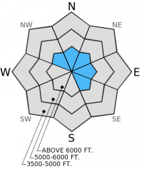
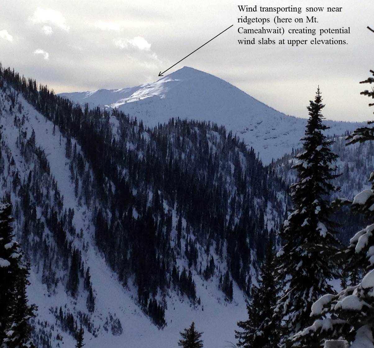
More mild weather and calm winds over the past 48 hours allowed wind slabs to settle and become less reactive. However, we observed a bit of wind loading at the upper most elevations yesterday near ridge tops, and stronger winds today could cause leeward slopes to become wind loaded again. Therefore, it is possible to trigger a wind slab today in these locations. Recognizing convex pillows and slopes of wind drifted snow and avoiding them is the best way to manage this problem.
-
Type ?
-
Aspect/Elevation ?

-
Likelihood ?CertainVery LikelyLikelyPossible
 Unlikely
 -
Size ?HistoricVery LargeLargeSmall

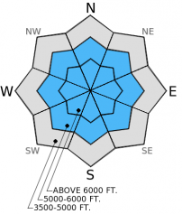
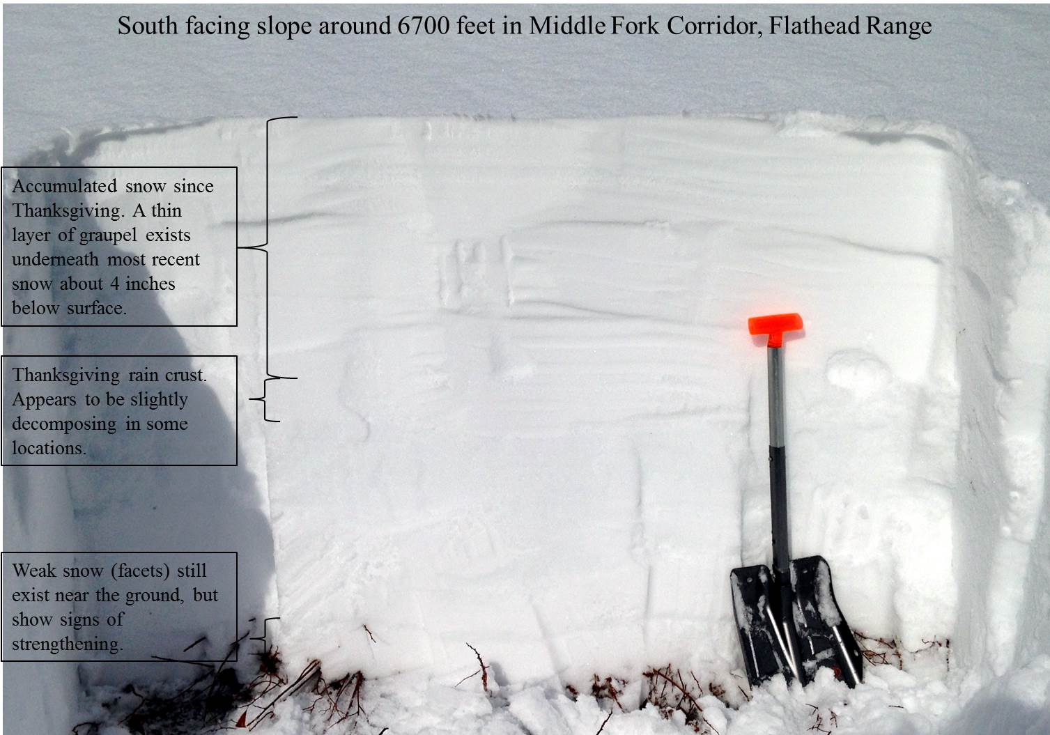
Weak snow (facets) near the ground appears to be strengthening due to recent warmer weather but still poses a persistent slab problem. This layer along with a layer of weak snow in the middle of the snowpack surrounding the Thanksgiving crust has become less reactive in stability tests. However, the snowpack is quite variable from one slope to another, and this layer still warrants caution. It is still possible to trigger an avalanche on this layer particularly on steep, rocky slopes with shallow snow. Avoiding these types of slopes and digging into the snow to evaluate the layer is important. So, for now, this problem still exists and requires a wide safety buffer to handle the uncertainty and variability.
Precipitation will begin this afternoon. Snow levels will start out around 5000-6000 feet and will rise tonight into tomorrow. Rain on snow adds a load very quickly to the snowpack not allowing the snowpack much time to adjust. While not a problem for most of the day, wet loose avalanches could become a problem later today as rain develops at lower elevations. So, pay attention to rapidly changing conditions.
The next scheduled advisory is Thursday, December 11, 2014.
Your observations are extremely important to us! If you are in the backcountry please drop us a line at [email protected], call us at 406.387.3835, or submit an obseravation on our Observations Page.
Yesterday, we traveled in to the Dickey Creek and Marion Lake drainages outside of Essex in the Flathead Range. We emerged from the valley fog around 5000 feet to warm temperatures and mostly sunny skies. A melt-freeze crust formed on the surface on sunny aspects up to about 5800 feet. Above that the sun and warm temperatures caused the snow surface to become moist. While we still found weak snow (facets) near the ground and in the middle of the snowpack in all of our snowpits (image), these layers were less reactive than in the past. The Thanksgiving crust still has weak snow surrounding it, but appears to be getting softer in a few locations. Wind slabs at the surface were less reactive during stability tests on wind loaded slopes. However, we observed some wind loading near the tops of ridges on nearby peaks (image).
Other observations from the weekend report similar results with both the wind slab and deeper instabilities showing signs of strengthening. A couple of the observations noted small wet sluffs and rollerballs on sunny aspects, and we observed these signs of wet snow instability yesterday as well.
Drier mountain weather shifts to the east as the first of several moist disturbances moves through the region later today. Currently, mountain temperatures range from 29º-39º F with winds out of the SW at 10-15 mph and gusts to 25 mph. Temperatures could reach the low 40s F today in the mountains and winds should be out of the southwest at 10-20 mph with gusts to 40 mph. Precipiation should begin this afternoon and expect snow levels to rise as a warmer air mass moves over northwest Montana.
| 0600 temperature: | 29-39 deg. F. |
| Max. temperature in the last 24 hours: | 39 deg. F. |
| Average wind direction during the last 24 hours: | SW |
| Average wind speed during the last 24 hours: | 5-10 mph |
| Maximum wind gust in the last 24 hours: | 26 mph |
| New snowfall in the last 24 hours: | 0 inches |
| Total snow depth: | 38-47 inches |
This advisory applies only to backcountry areas outside established ski area boundaries. This advisory describes general avalanche conditions and local variations always occur. This advisory expires at midnight on the posted day unless otherwise noted. The information in this advisory is provided by the USDA Forest Service who is solely responsible for its content.


